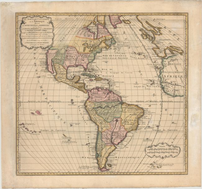
"Le Nouveau Continent ou l'Amerique Divisee en Septentrionale et Meridionale ou l'on Trouve les Climats les Meridiens les Differentes Possessions les Peuples Naturels Libres les Differentes Religions et les Differentes Langues", Leth, Hendrik de
Subject: Western Hemisphere - America
Period: 1739 (circa)
Publication: Nouvel Atlas, Geographique et Historique
Color: Hand Color
Size:
20.1 x 18.9 inches
51.1 x 48 cm
Henrik de Leth was successor to the Visscher firm and a skilled engraver as well as a mapseller and publisher. This map is from his last atlas and depicts the 'New Continent' in geographic and political detail. It describes climates, boundaries, colonial possessions, native people, religions and languages. In North America, the British colonies are confined to the eastern seaboard, and Floride ou Louisiane encompasses the majority of southern and central US. The northwestern portion of North America is left blank and marked as Mer Glaciale. In South America, the mythical lake Xarayes is prominently depicted near the center of the continent. The map is on Mercator's Equal-Area Projection, adding the graphic punch of the distorted longitudinal lines for a very handsome and dynamic appearance. Island groups are named and labeled with dates of their discovery. A very rare map.
References:
Condition: B+
Lovely original color with light soiling and a few tiny cracks caused by the oxidation of the green pigment, which have been closed on verso with archival tape.