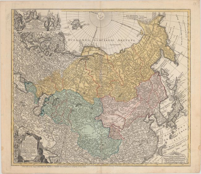
"Tartariae Maioris sive Asiaticae Tabula, quae Praesertim Complectit Tartariam Russicam, Tartariam Sinensem, et Tartariam Independentem sive Reliquam...", Haas/Homann Heirs
Subject: Northern Asia
Period: 1739 (dated)
Publication:
Color: Hand Color
Size:
21.6 x 18.8 inches
54.9 x 47.8 cm
This detailed chart of northern Asia extends from the Baltic, Black, and Caspian seas to include all of Russia and Siberia, and south to include Korea, Japan, China, and Taiwan. Political divisions, cities, and excellent topographical detail are shown. A misshapen and partially delineated Nova Zemlya appears with Spitsbergen visible to the north. The islands north of Japan in the Sea of Okhotsk are ambiguously rendered. A dedicatory cartouche in the top left corner honors Anna of Russia, who was empress at the time of the map's publication. Two hunters, one armed with a bow and arrow and the other with a rifle, take aim at a bear around the title cartouche. A third decorative cartouche at bottom right encloses three distance scales. Despite the 1730 date in the cartouche, this map was published after 1739, as indicated by a note beneath the lower neatline that notes the up-to-date boundary between Russia and Little Tartary.
References:
Condition: B+
There are a couple of printer's creases and an extraneous crease running parallel to the centerfold on the map's lower half.