Catalog Archive
Auction 149, Lot 570

Rare, Large Format Map of Malta

"A New Sea & Land Chart of the Sovereign Principality of Malta; Laid Down from the Best Authorities and the Different Manuscript Maps Communicated to the Chevr. Louis de Boisgelin...", Neele, Samuel John
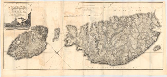
Subject: Malta

Period: 1804 (dated)

Publication: Ancient and Modern Malta…

Color: Black & White

Size:
50.8 x 21.6 inches
129 x 54.9 cm
Download High Resolution Image
(or just click on image to launch the Zoom viewer)

This rare, desirable and very detailed engraving depicts the islands of what is now called "The Republic of Malta", the southern-most of European countries. The map was published in Boisgelin's definitive history "Ancient and Modern Malta: Containing a Full and Accurate Account...." published in 1805. The map displays the larger islands of Malta, Gozo and lesser isles with a large pictorial title cartouche depicting a Knight of Malta reaching for a sinking ship flying a flag with a Maltese Cross. The detail is fine enough to include roads as well as structures in the rural areas. Topography is shown through dense hachuring, and the coastline is marked with soundings and anchorages. The Malta Historical Society has stated that "of all the printed maps of Malta, Boisgelin’s map is the second largest, coming only after the Carte Generale de la Principaute Souveraine des Isles de Malte et du Goze (53.1x 22.8"), made by Gervais de Palmeus and published in Paris in 1752." First edition, published by G. & J. Robinson, Pater-noster Row. Printed on two sheets, joined as issued.

References:

Condition: B

Issued folding with moderate offsetting and a few extraneous creases. There are several short splits at fold intersections and some small tears along the sheet edges confined to the blank margins, all of which have been closed on verso with archival tape.

Estimate: $2,500 - $3,500

Sold for: $1,800

Closed on 5/21/2014

Archived