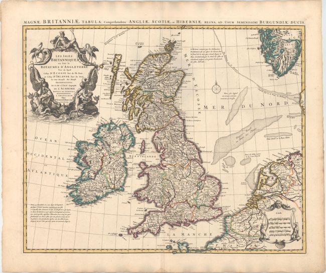
"Les Isles Britanniques ou sont le Royaumes d'Angleterre Tire de Sped Celuy d'Ecosse Tire de Th. Pont et Celuy d'Irlande Tire de Petti...", Delisle/Covens & Mortier
Subject: Britain
Period: 1730 (circa)
Publication:
Color: Hand Color
Size:
22.7 x 18.3 inches
57.7 x 46.5 cm
This is Covens & Mortier's reissue of Delisle's influential map of the British Isles that was first published in 1702. It is based on the foremost authorities: Speed for England and Wales, Pont for Scotland, and Petty for Ireland. The bottom right shows the coasts of the Netherlands, Belgium, and northern France and at the upper right is the southern tip of Norway. The important fishing banks in the North Sea are prominently illustrated and De Kimmen ou le Borneur traces what is now known to the edge of the European continental shelf. The note at lower left explains that Delisle doubts the existence of the islands of Brasil and Assmanda, which appeared on earlier maps. The large title cartouche incorporates mermen, fishing nets, sea birds and sea monsters and is surmounted by Neptune. Another decorative cartouche contains five distance scales flanked by hunting dogs.
References: Shirley (BI to 1750) Mortier 1.
Condition: A
Original color on a sturdy sheet of watermarked paper with a hint of offsetting and a tiny damp stain confined to bottom blank margin. There are some shadows that appear in the image that are caused by our scanner, and do not appear on the map itself.