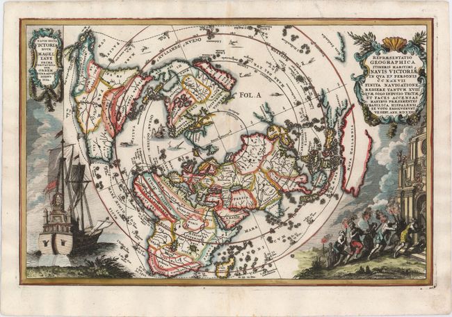
"Repraesentatio Geographica Itineris Maritimi Navis Victoriae in qua ex Personis CCXXXVII Finita Navigatione Rediere Tantum XVIII...", Scherer, Heinrich
Subject: North Pole, World
Period: 1700 (circa)
Publication: Atlas Novus
Color: Hand Color
Size:
14 x 9.1 inches
35.6 x 23.1 cm
This very graphic map is presented on a north polar projection and depicts all of the world except the South Pole, with California shown as an island. The map illustrates the remarkable circumnavigation led by Ferdinand Magellan. On the left is an illustration of Victoria, the only remaining ship from Magellan’s Armada de Molucca that sailed from Seville in 1519 in search of a westward route to the Spice Islands. On the right, the few expedition survivors (18 out of the original 237) are shown making their way to the Santa María de la Victoria church in Seville, where they went to give thanks for their safe return. The title cartouche includes the date of their return, September 7, 1522.
References: Shirley #626; Shirley (BL Atlases) T.SHER-1a #2.
Condition: A
A dark impression with a professionally repaired 1/2" centerfold separation in North America and a small abrasion near the center of the image.