Catalog Archive
Auction 149, Lot 406

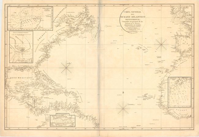
"Carta General del Oceano Atlantico Septentrional: Construida con Presencia de las Publicadas por la Direccion Hidrografica de Madrid y Otros Conocimientos Modernos", Direccion de Hidrografia

Subject: North Atlantic

Period: 1810 (dated)

Publication:

Color: Black & White

Size:
35.7 x 23.5 inches
90.7 x 59.7 cm
Download High Resolution Image
(or just click on image to launch the Zoom viewer)

This very uncommon sea chart was created by Jose de Espinosa y Tello de Portugal, an officer in the Spanish Royal Navy and Director of the Hydrographic Office in Madrid. The map details the Atlantic coastlines north of the Equator from Labrador to Brazil in the Americas and from Scotland to the Gulf of Guinea in the eastern hemisphere. Soundings, rocks, shoals, and fishing banks are noted along the coasts. The interiors of North America, South America and Africa are filled with insets detailing the waters surrounding Veracruz, the Yucatan, Havana, and Cadiz. The prime meridian runs through Cadiz. A note below the neatline at right indicates that the map was "engraved by the engraver employed by A. Arrowsmith."

References: Lowery #746.

Condition: B

Very light toning and offsetting with centerfold separations that enter 3.5" into map at top and bottom, and a 2" tear perpendicular to centerfold near the center of the map, all of which have been archivally repaired. There are also three archivally repaired edge tears: two enter 0.25" into map at bottom, and the third enters 1.5" into map at right. The bluish shadow that appears along the centerfold is caused by our scanner and does not appear on the map.

Estimate: $350 - $450

Unsold

Closed on 5/21/2014

Archived