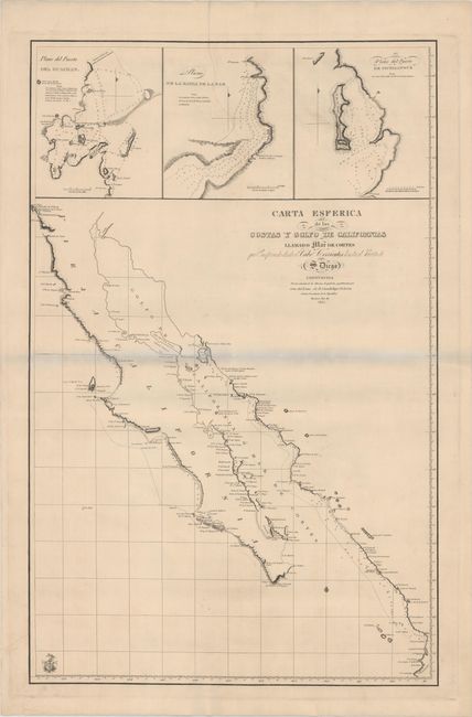
"Carta Esferica de las Costas y Golfo de Californias Llamado Mar de Cortes que Comprende Desde el Cabo Corrientes Hasta el Puerto de S. Diego...", Direccion de Hidrografia
Subject: Northwestern Mexico
Period: 1825 (dated)
Publication:
Color: Black & White
Size:
22 x 34.2 inches
55.9 x 86.9 cm
This rare sea chart was created for Guadalupe Victoria, the first president of Mexico shortly after Mexico gained independence from Spain. The map is a copy or a derivative of a map created in Spain by the Direccion de Hidrografia (Spanish Hydrographic Service). This map is one of a number of Spanish charts that were reissued in 1825 by the new Mexican government. The chart depicts Baja California (beginning at San Diego) and the eastern coastline of the Gulf of California south to C. Corrientes, which is just south of Puerto Vallarta. Soundings, rocks, shoals, and anchorages are noted along the coasts. Although the interior is left blank, the topography of the coastlines is illustrated by hachures. At top are three large insets depicting plans of the Port of Guaymas along the eastern coast of the Gulf of California, and the Bay of La Paz and Port of Pichilingue near the southern tip of Baja California.
References:
Condition: B+
A bright, clean example that has been backed with Japanese tissue to help reinforce an archivally repaired tear that enters about 10" into map at top. The bluish shadow that appears along the centerfold is caused by our scanner, and does not appear on the map.