Catalog Archive
Auction 149, Lot 249

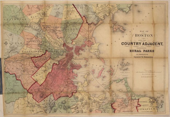
"Map of Boston and the Country Adjacent, Showing Rural Parks as Proposed by Ernest W. Bowditch", Williams, Alexander

Subject: Boston, Massachusetts

Period: 1878 (circa)

Publication:

Color: Hand Color

Size:
25.1 x 17.1 inches
63.8 x 43.4 cm
Download High Resolution Image
(or just click on image to launch the Zoom viewer)

This uncommon pocket map of the greater Boston area is printed on fine banknote-style paper. It covers the region from Cohasset in the south, north to Swampscott, and westward to Lexington in the northwest and Dedham in the southwest. Concentric circles are spaced at one mile intervals from the State House in Boston to indicate distance from the city. The map has good detail including railroads, wagon roads, and major streets, which are identified in the larger towns including Boston, Roxbury and Chelsea. Drawn on a scale of one mile per inch. There is a pencil inscription on the back of the map "Katie B. Parks 1878" which helps to date the undated map. Folds into green cloth covered boards (4 x 5.5") with gilt title on front cover.

References:

Condition: B

Issued folding with light toning, a few small stains along the folds, and several short splits at fold intersections that have been closed on verso with archival tape. Covers show minor wear.

Estimate: $300 - $375

Sold for: $220

Closed on 5/21/2014

Archived