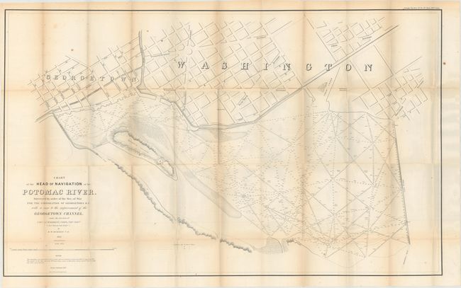
"Chart of the Head of Navigation of the Potomac River. Surveyed by the Order of the Sec. of War for the Corporation of Georgetown D.C. with a View to the Improvement of the Georgetown Channel…", U.S. War Department
Subject: Washington, D.C.
Period: 1857 (dated)
Publication: Sen. Ex. Doc. No. 34, 35th Cong., 1st Sess.
Color: Black & White
Size:
40 x 24.6 inches
101.6 x 62.5 cm
This uncommon map shows a portion of Georgetown and Washington D.C. along the Potomac River, and includes part of the Chesapeake and Ohio Canal as well as Rock Creek and the Basin. Names the major streets and shows the location of the Washington Monument. Within the Potomac River are hundreds of soundings with notes on the bottom material. Place names mentioned include Alexandria Road, the Alexandria Canal, Mason's Island and Timber Creek. Made under the direction of Capt. L. C. Woodruff by R.W. Burgess of the Topographical Engineers. Engraved by Denis Callahan and printed by the esteemed firm of Julius Bien. A seldomly seen issue that should not be confused with the smaller reprint issued in 1891.
References:
Condition: B
Issued folding with numerous short splits at fold intersections, light toning along the folds, and a few spots of foxing.