Catalog Archive
Auction 149, Lot 223

One of the Earliest Maps of Connecticut Published in America

"Connecticut from the Best Authorities", Doolittle, Amos

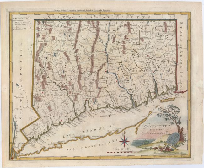
Subject: Connecticut

Period: 1795 (circa)

Publication: Carey's General Atlas

Color: Hand Color

Size:
14.6 x 11.8 inches
37.1 x 30 cm
Download High Resolution Image
(or just click on image to launch the Zoom viewer)

This is one of the earliest maps of Connecticut published in America. The map was drawn and engraved by Amos Doolittle for Matthew Carey's American edition of Guthrie's Geography Improved, published in 1795. The map also appeared in Carey's American Atlas the same year, and in Carey's General Atlas in 1800 with the addition of a plate number (as seen on this example). Towns and town lines are based on William Blodget's map circa 1791, but the coastline and rivers are from a different unknown source. The map shows the Oblong, an area of dispute between Connecticut and New York. The boundary line is shown following the Byram River from Long Island Sound to a point in line with the 3 Trees that were used as an early boundary marker. The map is finely detailed showing counties, topography, towns, churches, courthouses, and roads. The county lines are current for 1795, just prior to Hartford County gaining additional land from Litchfield County along the northern border of the state. This is the second state with the addition of the 3 Trees, published in Carey's General Atlas in 1800. An important map for Connecticut collectors.

References: Wheat & Brun #284; Thompson #36; McCorkle #C795.1.

Condition: B+

Minor toning with professional repairs to a chip in right blank margin and two tiny infilled holes in image at top right and in bottom border.

Estimate: $600 - $750

Sold for: $425

Closed on 5/21/2014

Archived