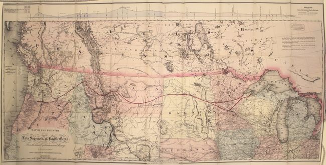
"Map of the Country from Lake Superior to the Pacific Ocean From the Latest Explorations and Surveys... [with] Memorial of the Board of Directors", Colton, G.W. & C.B.
Subject: Northwestern United States
Period: 1867 (dated)
Publication:
Color: Hand Color
Size:
44.7 x 21.8 inches
113.5 x 55.4 cm
This large and very detailed railroad map covers from Detroit west to the Pacific, well into Canada and south to about the 39th parallel and the Great Salt Lake. It is absolutely filled with detail, including the Pony Express route, overland mail routes, Fremont's exploration routes and dates, proposed and existing railroads, wagon roads, isothermal lines and forts. Along the top is a profile of the Northern Pacific Route across the country. The Northern Pacific had a stormy career that endured recessions, mergers, poor cost controls, etc. It was not until 1883 that it actually became a transcontinental railroad. This is a terrific and scarce map that displays an amazing amount of detail.
The map is still bound into the 56 pp. octavo report which includes a section from the Chief Engineer, Edwin F. Johnson.
References: Wheat (TMW) #1169.
Condition: A
Condition code is for the map which is clean and bright with just a few fold separations closed on verso with archival tape. The report is very good with some minor chips to the fore edge of the first few pages and the wrappers are not present.