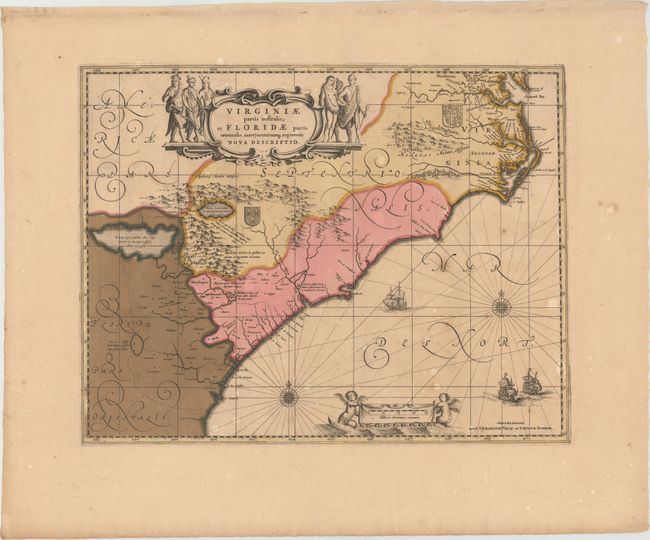
"Virginiae Partis Australis, et Floridae Partis Orientalis, Interjacentiumq Regionum Nova Descriptio", Valck and Schenk
Subject: Colonial Southeast
Period: 1709 (circa)
Publication:
Color: Hand Color
Size:
19.4 x 15.1 inches
49.3 x 38.4 cm
This lovely map of the Southeast extends from the southern part of Chesapeake Bay to northern Florida. This is the second state of Jansson's map, which is virtually identical to Blaeu's map of 1638. Cartographically it improves on the Hondius map of 1606, on which it was derived, with Chesapeake Bay correctly indicated as a large bay and the Carolinas and Georgian coasts depicted more accurately. The map presents the English and French colonial interests in the region as depicted by their respective royal arms. At the southern end of the Appalachians is a note concerning gold and silver mines. Richly decorated with a large cartouche flanked by Native Americans. The Atlantic Ocean contains two compass roses, three sailing ships and two aquatic putti holding the German scale of miles. Petrus Schenk acquired the plate from Jansson's heirs and reissued the map with his own imprint and with the addition of lines of latitude and longitude.
References: Burden #254; Cumming (SE) #42.
Condition: B
A nice impression with original color and very wide margins. There are some small, scattered stains, one tiny hole in an unengraved area of map, and some cracks caused by the oxidation of the green pigment that have all been archivally repaired.