Catalog Archive
Auction 148, Lot 98

"The English Empire in America, Newfound-Land, Canada, Hudson's Bay. &c. in Plano", Moll, Herman

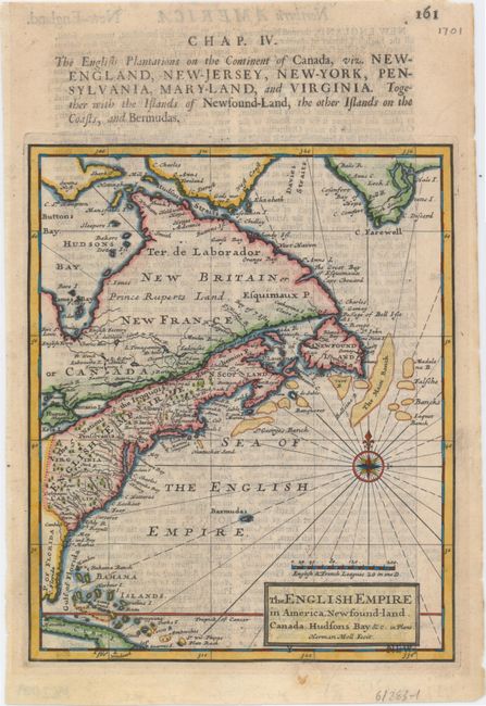
Subject: Colonial North America & West Indies

Period: 1701 (published)

Publication: A System of Geography

Color: Hand Color

Size:
7 x 8.5 inches
17.8 x 21.6 cm
Download High Resolution Image
(or just click on image to launch the Zoom viewer)

This fascinating map of English possessions in North America stretches from Cuba to the southern tip of Greenland. There is good detail throughout the eastern seaboard, with many rivers named and important settlements and cities such as Jamestown, Plymouth, Boston, Baltimore, Philadelphia, and Charleston located. The boundaries of Virginia extend north to Lake Erie, and Pennsylvania's northern border nearly reaches the St. Lawrence River. A note pointing out The 5 Nations of the Iroquois spans from Virginia to Montreal. The St. Lawrence River, Hudson's Bay, Lake Ontario, and Lake Erie all appear in a roughly accurate configuration. A compass rose capped with a fleur-de-lys and radiating rhumb lines adorns the Atlantic, referred to here as the Sea of the English Empire. Moll's System of Geography was essentially a larger version of Thesaurus Geographicus of 1695. The additional maps included in System of Geography were stamped "NEW," as seen here below the title cartouche. English text on verso.

References: Phillips (A) #536-161; Shirley (BL Atlases) T.MOLL-1b. #35.

Condition: B+

A fine impression with light show-through of text on verso.

Estimate: $350 - $425

Sold for: $225

Closed on 2/19/2014

Archived