Catalog Archive
Auction 148, Lot 222

Early Air Navigation Map

"Airway Map No. 105 Kansas City, MO., to Moline, Ill.", U.S. Coast & Geodetic Survey

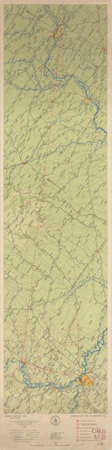
Subject: Central United States

Period: 1928 (dated)

Publication:

Color: Printed Color

Size:
10.2 x 43.1 inches
25.9 x 109.5 cm
Download High Resolution Image
(or just click on image to launch the Zoom viewer)

In 1921, the United States Army Air Corps initiated a compressive evaluation of aeronautical charts in an effort to develop a standardized map for aerial navigation. Based upon this study, the Air Corps issued 63 air navigation maps covering most of the military routes in the United States. Prior to 1926, these maps were jointly compiled by the Geodetic Survey and U. S. Army Engineer Reproduction Plant. By 1926, the preparation of air maps were fully compiled by the U.S. Coast and Geodetic Survey (under the Commerce Department) with the passage of the Air Commerce Act. Maps from this point on were intended to merge the growing commercial airways system with the military network.

This map covers the area from Kansas City, Missouri to Moline, Illinois and shows elevation and contours, cities and towns, rivers, roads and railroads. Airfield classifications are shown with different symbols including seaplane landings. True north and magnetic north are depicted. On a scale of 8 miles per inch.

References:

Condition: A

A colorful example with some minor soiling at top and bottom. Backed in linen. Ex-library stamp on verso.

Estimate: $80 - $100

Sold for: $80

Closed on 2/19/2014

Archived