Catalog Archive
Auction 148, Lot 213

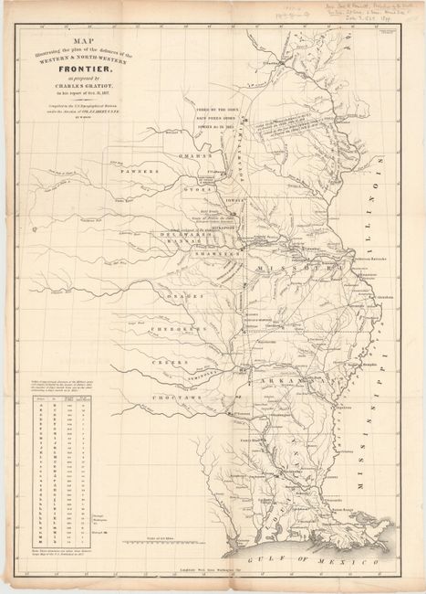
"Map Illustrating the Plan of the Defences of the Western & North-Western Frontier, as proposed by Charles Gratiot, in his report of Oct. 31, 1837", Gratiot, Charles

Subject: Central United States

Period: 1837 (dated)

Publication: HR Doc 311 25th Cong 2nd Sess.

Color: Black & White

Size:
15 x 21 inches
38.1 x 53.3 cm
Download High Resolution Image
(or just click on image to launch the Zoom viewer)

This map is from the series of maps that illustrated the factious Congressional debate over the nature of the frontier defenses in the region between the Mississippi River and the Rocky Mountains. Issued under the direction of Col. J. J. Abert by W. Hood, the map depicts the states of Missouri, Arkansas, Louisiana and the Indian nations bordering them to the west. It shows the locations of many military forts and outposts from Ft. Jessup to Ft. Snelling with notations throughout concerning lands ceded by several Indian nations with the dates of the treaties. The threat posed by hostile Indians, whose numbers greatly exceeded those of the area's settlers, resulted in a protracted Congressional debate concerning the defenses required along the frontier. A table at lower left notes the distances between forts and the equivalent "days of march" at 15 miles per day.

References: Wheat [TMW] #427; Claussen & Friis #183.

Condition: B+

Issued folding with light soiling and several short fold separations and edge tears that just enter map border and have been closed on verso with archival tape. There are a few tiny chips in blank margins and some pencil notations in the top blank margin.

Estimate: $250 - $325

Sold for: $135

Closed on 2/19/2014

Archived