Catalog Archive
Auction 147, Lot 746

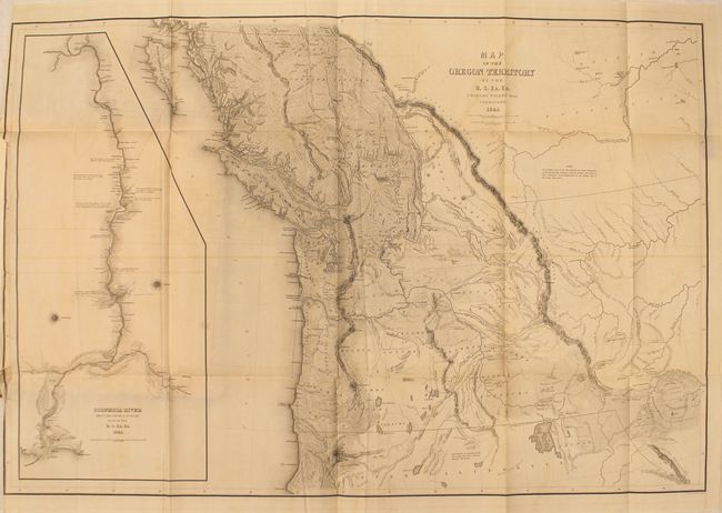
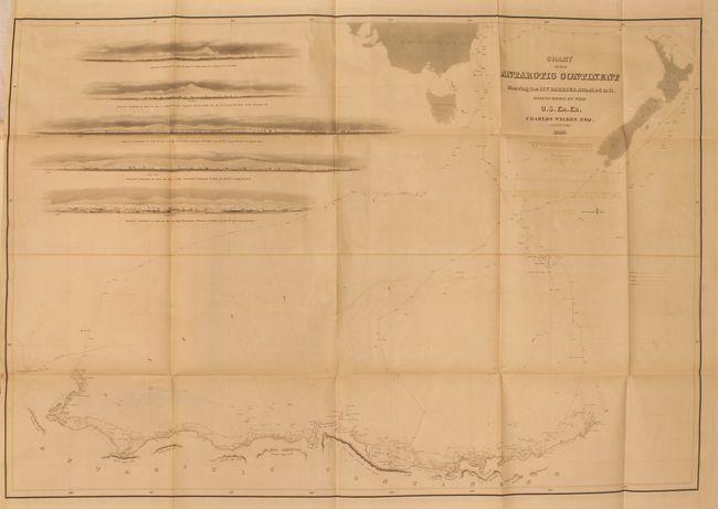
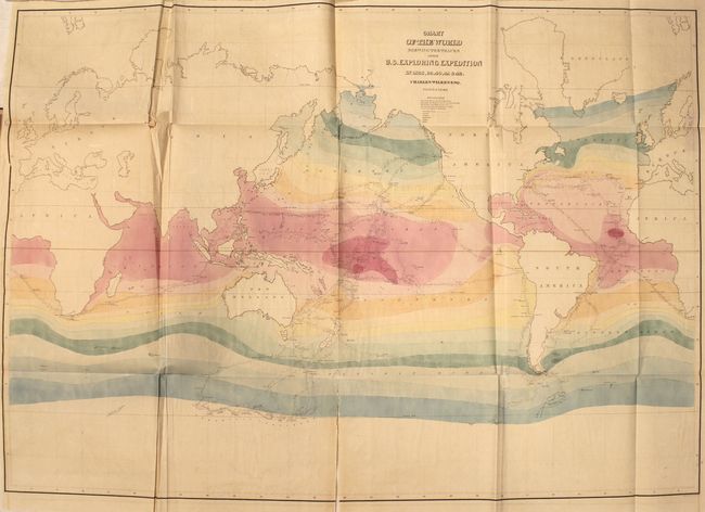
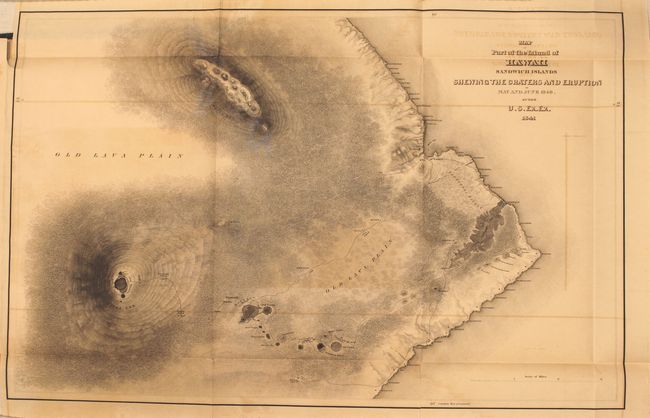
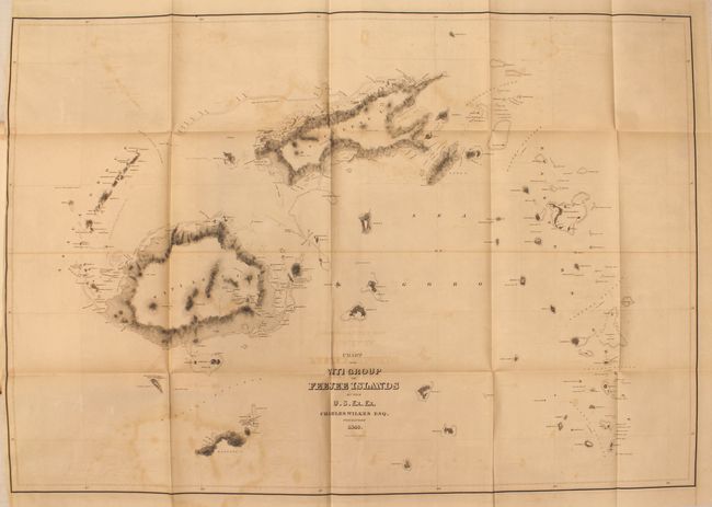
Very Rare First Edition Atlas of Wilkes' Expedition

"Atlas. Narrative of the United States Exploring Expedition. During the Years 1838, 1839, 1840, 1841, 1842", Wilkes, Charles

Subject: Exploration and Surveys

Period: 1844 (published)

Publication:

Color:

Size:
9.8 x 13.5 inches
24.9 x 34.3 cm
Download High Resolution Image
(or just click on image to launch the Zoom viewer)

This is the atlas volume from the very rare first edition of the Wilkes' Expedition (with only 100 copies printed) that accompanies Wilkes' five volume narrative of the Exploring Expedition, which was one of the most important American scientific expeditions of the 19th century. It was the first U.S. Naval expedition, taking in the Northwest Coast, Hawaii, South America, the Philippines, the South Pacific, Australia and Antarctica. The expedition broke new ground in most areas of natural history and made a number of extremely important cartographic discoveries, most importantly establishing that Antarctica was a continent. They mapped 280 islands in the Pacific for the first time and included extensive and graphically rich ethnographic records of many native peoples throughout the Pacific. The five maps included in this volume are:

Map of the Oregon Territory...., dated 1841, black & white (33.8 x 22.8"). An important map that Wheat says is "really quite extraordinary" and in many respects was the most detailed yet published. The map covers the entire region west from the Black Hills, north to above the 50th parallel and south to the Sacramento River. The United States Exploring Expedition did not enter the Great Basin or any part of the Snake River basin. Instead Wilkes relied on other sources including Jedediah Smith and oral information from Hudson Bay trappers he met on the Columbia River. Although the map contains several errors, the areas of today's Oregon, Washington and Idaho are remarkably well mapped. According to Wheat the map had much influence on later maps of this region. It was a major contribution to American cartography and the most detailed map of the region north of the Sacramento River. Wilkes supported the view of Senator Lewis Linn that the boundary of the American claim should be 54° 40' N, commonly referred to as "Fifty-Four Forty or Fight" dispute with Britain. This map was used to support his claim, which was based on 'topographical' grounds and was instrumental in setting the scene for American interests in the territory. Includes a large inset of the Columbia River from Ft. Walla Walla to its mouth, where one of Wilkes' ships, the "Peacock", was lost on the famous Columbia Bar. This map is considered one of the more important maps of the Northwest region after the Lewis & Clark expedition.

Chart of the Antarctic Continent Shewing the Icy Barrier Attached to it..., dated 1840, black & white (34 x 23.5"). This map represented a major advance in establishing Antarctica as a true continent, thus helping to settle the cartographic mystery of its existence which had been debated by explorers and mapmakers for centuries. It is a detailed map of Antarctica and the southern Pacific Ocean centered on the longitude of Van Diemens Land. It shows Antarctica from about longitude 95° West to 170° with surprisingly good detail along the coastline. Numerous Ice Islands clog the bays and seas near land and many air and water temperatures are noted. The tracks of the ships Vincennes, Peacock, Porpoise, and Flying Fish are detailed. At upper left are five sea approach views.

Chart of the World Shewing the Tracks of the Exploring Expedition in 1838, 39, 40, 41 & 42..., circa 1844, hand color (32.2 x 23.3"). This detailed map shows the tracks of the Expedition vessels along with the direction and velocity of ocean currents and trade winds. Isothermal lines are delicately colored to indicate water temperature in five degree groupings.

Map of Part of the Island of Hawaii Sandwich Islands Shewing the Craters and Eruption of May and June 1840..., dated 1841, black & white (23.6 x 15.3"). This map depicts two volcanic mountains visited by the Expedition and includes the track of the party to the crater of Moku-a-weo-weo on the top of Mauna Loa.

Chart of the Viti Group or Feejee Islands..., dated 1840, black & white (33.8 x 23.5"). Shows very good detail of the 154 islands in the group including coastlines, coral reefs, and topography by hachure.

Hardbound in brown cloth over boards. Printed by C. Sherman in Philadelphia.

References: Wheat (TMW) #457; Phillips #3245; Howes #W414.

Condition: B

The maps are generally good with light toning and offsetting. The colored map of the world has two moderate splits at fold junctions and a separation at bottom that enters 5.75" into the map image, while the map of Hawaii has a separation at bottom that enters 1.25" into the image. The spine has perished (this is not the original binding), the covers are detached, and the front endpapers and title page loose.

Estimate: $3,000 - $4,000

Sold for: $3,250

Closed on 11/20/2013

Archived