Catalog Archive
Auction 147, Lot 465

"Intervalla Viaeque Publicae Electoratus Saxoniae…", Seutter, Albercht Karl

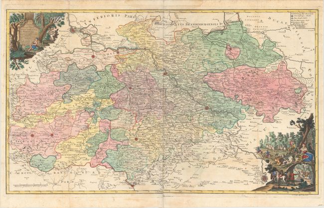
Subject: Eastern Germany

Period: 1756 (circa)

Publication:

Color: Hand Color

Size:
37.8 x 22.3 inches
96 x 56.6 cm
Download High Resolution Image
(or just click on image to launch the Zoom viewer)

This is a rare and extremely interesting postal map of Saxony. The map is centered on the course of the Elbe, from Magdeburg to Prague and extends from Gotha to the Silesiae (Polish) boundary. It emphasizes the postal roads with the distances between the larger towns and villages noted. The large map is embellished with a title cartouche and a quaint allegorical scene showing the messenger, Mercury, in a chariot drawn by four Pegasus steeds, and another of the hunting goddess, Diana, in her chariot drawn by a pair of stags. Printed on two joined sheets, as issued.

References:

Condition: B+

Issued folding, with two tiny splits at fold intersections, minor toning and soiling, and some light damp stains in the margins.

Estimate: $300 - $400

Sold for: $200

Closed on 11/20/2013

Archived