Catalog Archive
Auction 146, Lot 211

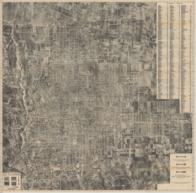
"Aerial Photomap of Pasadena",

Subject: Pasadena, California

Period: 1922 (dated)

Publication:

Color: Black & White

Size:
31.4 x 31.3 inches
79.8 x 79.5 cm
Download High Resolution Image
(or just click on image to launch the Zoom viewer)

The is a very uncommon and detailed photo-lithographic map of Pasadena that was photographed from an elevation of 8,000 feet above the city. This early aerial map shows street names, railroads, electric railways superimposed over the 'satellite' image. Major streets are further called out by line and major complexes are named. The scale is about 12" to a mile. The detail is not up to modern aerial photography standards but is adequate enough for one to make out individual houses and other structures. Early earthwork for the construction of the Rose Bowl ("Stadium Site") can be seen at the left. An aerial view would have been foreign to the average citizen so the legend uses example photographs to show how business and residential sections, orchards and fields appear from the air. Published for the First Bank of Pasadena as a free give-away promotional map of the city.

The verso has a panel that indicates the map was made especially for the FIRST BANK by the Photomap Company of Pasadena, plus 10 aerial views of the city as well as promotional and bank information. This is an early aerial photography map that was not produced for military purposes. Printed on news print paper and published by the Western Litho Co., Los Angeles, CAL.

References:

Condition: B+

There are a number of short splits at fold intersections that have been closed on verso with archival tape and some faint toning along the folds.

Estimate: $200 - $250

Unsold

Closed on 9/4/2013

Archived