Catalog Archive
Auction 146, Lot 204

"Preliminary Sketch of Santa Barbara California", U.S. Coast Survey

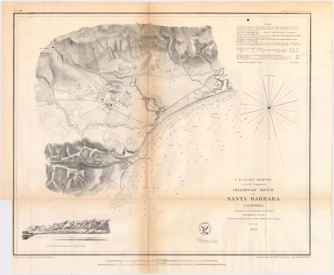
Subject: Santa Barbara, California

Period: 1853 (dated)

Publication:

Color: Black & White

Size:
16.8 x 13.8 inches
42.7 x 35.1 cm
Download High Resolution Image
(or just click on image to launch the Zoom viewer)

The Office of Coast Survey is the oldest U.S. scientific organization, dating from 1807 when Congress directed that a "survey of the coast" be carried out. By 1836, it was called the U.S. Coast Survey and in 1878, the name was changed to the U.S. Coast and Geodetic Survey. Today the Office of Coast Survey is a division of the National Oceanic and Atmospheric Administration NOAA.

The survey teams, composed of civilians as well as Army and Naval officers, charted the nation's waterways and produced a wide array of reports, survey charts, hydrographic studies of tides and currents, astronomical studies and observations, and coastal pilots. These charts are an important record of the changing nature of the nation's coastlines. In additional to coastal charts, the U.S. Coast and Geodetic Survey produced land sketches, Civil War battle maps, and the early aeronautical charts.

This chart provides excellent detail along the coast and inland to include individual city buildings in the street plan of Santa Barbara. Las Salinas, The Mission, the Observatory on the coast, and Point Castillo are located. At lower left is the profile "View of the Town and Mission of Santa Barbara" as seen from the sea. This is the only Coast Survey work done on Santa Barbara.

References:

Condition: B

Issued folding with toning along the folds and a binding trim at lower left.

Estimate: $150 - $180

Sold for: $75

Closed on 9/4/2013

Archived