"Generalis Totius Imperii Moscovitici Novissima Tabula Magnam Orbis terrarum partem a Polo Arctico sife ad mare Japonicum et Chinae Septentrionalis…", Homann, Johann Baptist
Subject: Northern Asia
Period: 1725 (circa)
Publication: Neuer Atlas…
Color: Hand Color
Size:
22.5 x 19.2 inches
57.2 x 48.8 cm
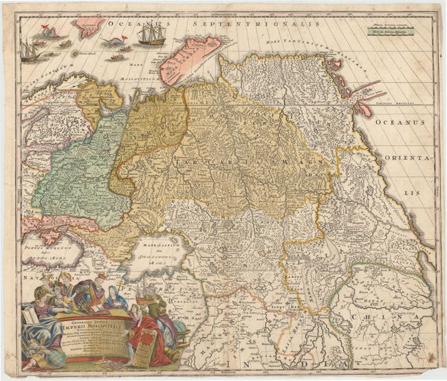
This large map shows the whole of Russia from the Black Sea and the Baltic to Kamchatka, China, and Northern India. Just above the Arctic Circle, Witsen's mountainous peninsula (Scopuli) is shown with an unknown eastern coastline. Beautifully engraved and highly detailed, the map shows forests, watershed, roads, and many tiny villages. A very elaborate cartouche embellishes the lower corner with historical figures, a ship, globes and putti. The sea at upper left is filled with two sailing ships and several rowboats with men harpooning sea monsters. This is an early state, with a truncated coast of Siberia, based on E. W. Ides' map of 1707.
References: Shirley (BL Atlases) T.HOM-1a #40.
Condition: C+
Light soiling with archival repairs to a long centerfold separation, an 8" tear that extends to the left of the centerfold, and several small tears that just enter map image. There are a few tiny worm holes in image and two small chips at bottom, with loss of border.