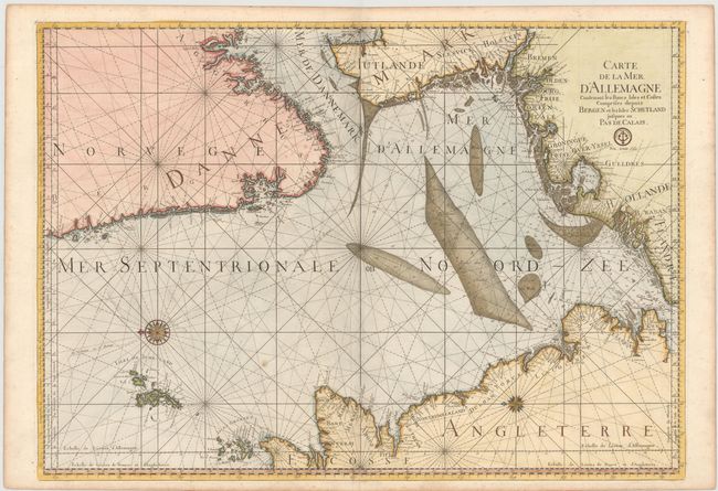
"Carte de la Mer d'Allemagne Contenant les Bancs Isles et Costes Comprises Depuis Bergen et les Isles Schetland Jusques au Pas de Calais", Bellin, Jacques Nicolas
Subject: North Sea
Period: 1773 (published)
Publication: La Neptune Francois…
Color: Hand Color
Size:
33.9 x 24.1 inches
86.1 x 61.2 cm
Fine, large sea chart of the North Sea and Skagerrak (Mer de Dannemark) and adjacent coastlines. Includes the Shetland and Orkney Islands. Superb detail throughout especially of the mud flats of North, East, and West Frisia, the sands in the Channel, and the mouth of the Thames. The chart is oriented with north to the left with two unusual and very beautiful compass roses, one incorporating the sun symbol of Louis XIV. Beautifully engraved by Herman van Loon. This is a Depot de la Marine issue with the seal and the price (Prix trente Sols) below the title.
References: Pastoureau, NEPTUNE FRANCAIS D #5.
Condition: B+
A fine impression and attractive color on heavy, watermarked paper with light soiling and a couple of tiny worm tracks adjacent to centerfold at bottom of map.