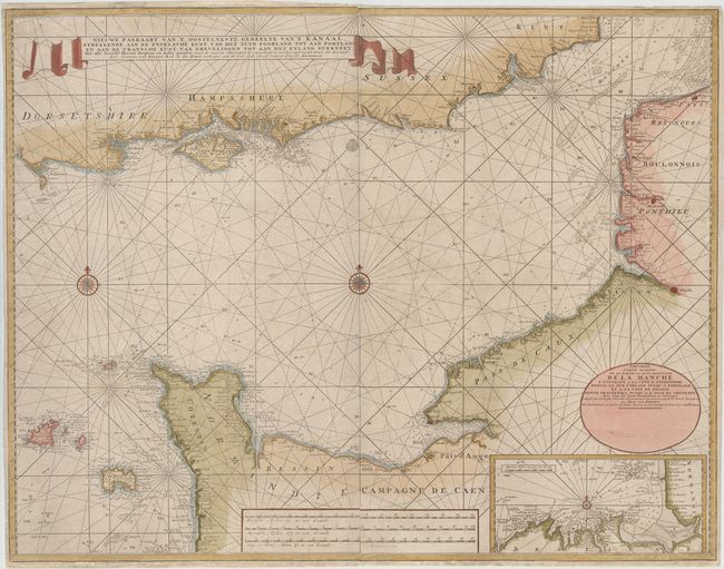
Scarce Chart of the English Channel
"Nieuwe Paskaart van 't Oostelykste Gedeelte van 't Kanaal, Strekkende aan de Engelsche Kust, van het Zuyd Foorland tot aan Portland, en aan de Fransche Kust...", Keulen, Johannes van
Subject: English Channel
Period: 1730 (circa)
Publication:
Color: Hand Color
Size:
41.8 x 32.7 inches
106.2 x 83.1 cm
This scarce, large-scale chart shows the English Channel and features great navigational information depicted along the coastlines with soundings, banks, rocks, currents, and safe anchorages. The chart shows the English coast from Dorsetshire to Kent, and the French coast from the Channel Islands and the Cotentin Peninsula to Gravelines. An inset chart at bottom right depicts the northern coast of Bretagne. A French title is contained in a separate cartouche at bottom right: Nouvelle Carte Marine de la Partie la Plus Orientale de la Manche… Printed on four sheets, joined. We could not find any other examples of this map being offered on the market in the last 30 years, and only a few examples in libraries.
References:
Condition: B+
A nice impression on watermarked, mottled paper with attractive color, minor soiling, and an old manuscript notation below the distance scales. There is a tiny hole caused by a rust stain at top center, and several professionally repaired chips in blank margins that extend into map border, with border expertly replaced in facsimile. Overall a very nice example for such a large chart.