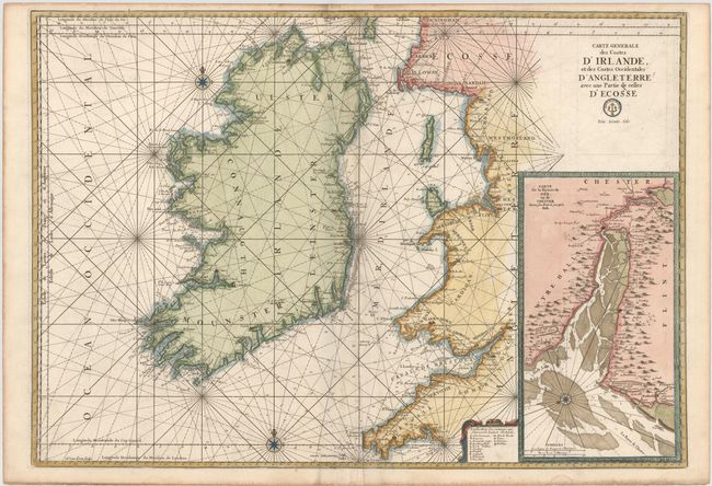
"Carte Generale des Costes d'Irlande, et des Costes Occidentales d'Angleterre avec une Partie de Celles d'Ecosse", Bellin, Jacques Nicolas
Subject: Ireland
Period: 1773 (published)
Publication: La Neptune Francois…
Color: Hand Color
Size:
34.5 x 24 inches
87.6 x 61 cm
This superb, large-scale chart covers Ireland and the Irish Sea to include part of England's west coast and the southwestern coast of Scotland. The coastal areas of Ireland are filled with detail, but the interior areas are left mostly blank. Locates the cities of Londonberry, Belfast, Corck, Waterford, Lymerick and Galloway. The large inset at right has its own fancy border and details the region just south of Liverpool to show the River Dee and the towns of Chester, Flint and Holt. The chart is embellished by rhumb lines and a separate fancy cartouche surrounding the legend. Engraved by Hermann van Loon. With the seal of the Depot de la Marine and the cost Prix, trente sols engraved below the title.
References: Pastoureau, NEPTUNE FRANCAIS D #10.
Condition: B+
A fine impression and attractive color on heavy, watermarked paper with minor offsetting and light soiling.