"[A Map of the British Empire in America (Sheet 15) - Dominican Republic, Puerto Rico, Leeward Islands]", Popple, Henry
Subject: Dominican Republic, Puerto Rico, Leeward Islands
Period: 1733 (circa)
Publication:
Color: Hand Color
Size:
26.8 x 19.2 inches
68.1 x 48.8 cm
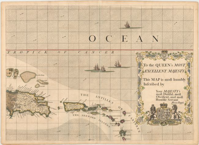
Four intricately drawn ships navigate the ocean currents of this finely engraved map. This is sheet 15 of Popple's 20-sheet map of the British Empire in North America, focusing on the eastern half of Hispaniola, Puerto Rico, and the Leeward Islands through Dominica. The map shows place names, topography, wind direction arrows, and shoals. The map is dominated by an elaborate dedication cartouche that reads "To the Queen's most excellent majesty this map is most humbly inscribed by your majesty's most dutiful, most obedient, and most humble servant Henry Popple." Another feature of the map is the political use of color, with red for British possessions, yellow for Spanish colonies, and blue (here oxidized to green) for French claims.
Popple based his map on firsthand information gathered over several years at the Board of Trade and Plantations. The map was the first large-scale British map to provide an overall view of the eastern half of North America. As tensions grew between the colonial powers, the map became immensely influential throughout Europe and was copied by several cartographers. This is an early state printed on sturdy paper with no page number in top margin.
References: Pritchard & Taliaferro, pp. 134-141.
Condition: B+
Watermarked paper with original color in map and later color in dedication cartouche, light offsetting, and a few minute worm holes only visible when held to light.