Catalog Archive
Auction 145, Lot 294

"Reconnaissance of Port Royal Entrance and Beaufort Harbor South Carolina", U.S. Coast Survey

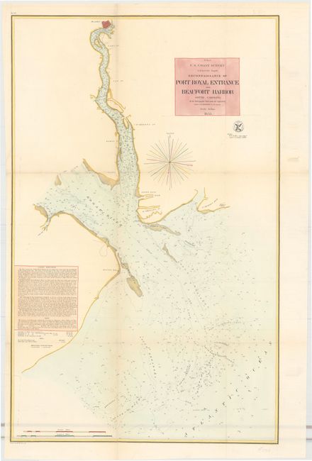
Subject: Beaufort, South Carolina

Period: 1855 (dated)

Publication:

Color: Hand Color

Size:
17 x 27.3 inches
43.2 x 69.3 cm
Download High Resolution Image
(or just click on image to launch the Zoom viewer)

The Office of Coast Survey is the oldest U.S. scientific organization, dating from 1807 when Congress directed that a "survey of the coast" be carried out. By 1836, it was called the U.S. Coast Survey and in 1878, the name was changed to the U.S. Coast and Geodetic Survey. Today the Office of Coast Survey is a division of the National Oceanic and Atmospheric Administration NOAA.

The survey teams, composed of civilians as well as Army and Naval officers, charted the nation's waterways and produced a wide array of reports, survey charts, hydrographic studies of tides and currents, astronomical studies and observations, and coastal pilots. These charts are an important record of the changing nature of the nation's coastlines. In additional to coastal charts, the U.S. Coast and Geodetic Survey produced land sketches, Civil War battle maps, and the early aeronautical charts.

This survey chart shows the entrance to Port Royal, situated between the Beaufort River and Broad River. Several islands are shown, including a portion of Hilton Head Island at the lower left. The town of Beaufort is shown at top center. Complex soundings fill the chart along with notations on banks, breakers, and channels.

References:

Condition: B+

Issued folding and now flattened with light toning along the folds and a few short splits and small holes at fold intersections repaired on verso with archival material.

Estimate: $140 - $170

Sold for: $100

Closed on 6/12/2013

Archived