"[Lot of 2] Sketch of Vicinity of Fort Fisher… [and] Plan and Sections of Fort Fisher…", U.S. Army
Subject: North Carolina, Civil War
Period: 1866 (published)
Publication: Report of Chief Engineer U.S.A., 39th Congress, 1st Session
Color: Black & White
These maps are plates No. 5 and No. 6 from the report and are early published Civil War maps; most reports and maps withheld publication until the 1890's to allow time for the national wound to heal sufficiently for a public discussion of the conflict.
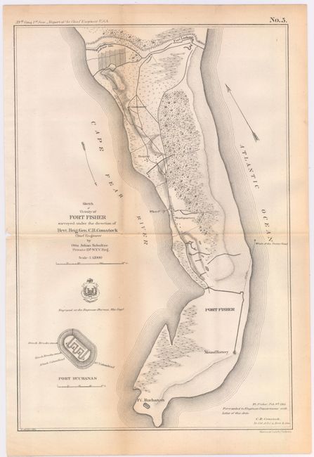
A. Sketch of Vicinity of Fort Fisher Surveyed Under the Direction of Brvt. Brig. Gen. C.B. Comstock Chief Engineer, (9.8 x 14.4"). Provides good detail of the peninsula, locating Ft. Buchanan, Mound Battery, Fort Fisher, headquarters, Wharf, Hospital, the Commissary and Fort Lookout to the north. Also locates the Wreck of the "Powder Vessel" some 830 yards north of Fort Fisher.
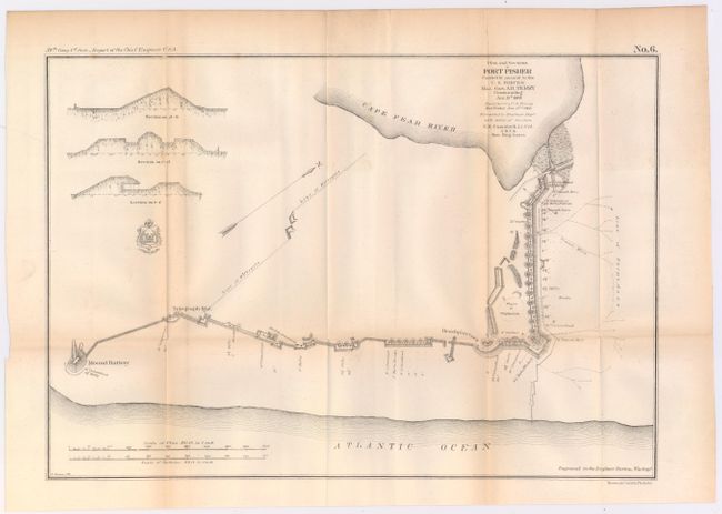
B. Plans and Sections of Fort Fisher Carried by Assault by the U.S. Forces Maj. Gen. A.H. Terry Commanding Jan. 15th 1865, (15.3 x 10.6"). Very close detail of the Fort to show the position of all armament along the fortified walls. Locates cannon ("rifle") locations including the huge Columbia 10" cannons at each end with many smaller (4.5" to 8") cannons positioned between. The map shows Electric Wires leading out from the walls to a Line of Torpedoes protecting the open ground beyond the fort's wall. It is quite rare to see this type of weapon mentioned on a map. Further research shows electrically triggered land-based torpedoes were used as early as during the Crimean War, 1854-1856.
References: Stephenson (CW) #311 & #315.
Condition: B+
Issued folding with light toning along the folds.