Issued for Use by the French Navy during the American Revolution
"Plan de l'Ile d'Amelia... [on sheet with] Plan de la Barre et du Port d'Amelia... [and] Plan de la Barre et de l'entree de la Riviere de Nassau", Depot de la Marine
Subject: Florida
Period: 1779 (dated)
Publication:
Color: Black & White
Size:
17.3 x 23.2 inches
43.9 x 58.9 cm
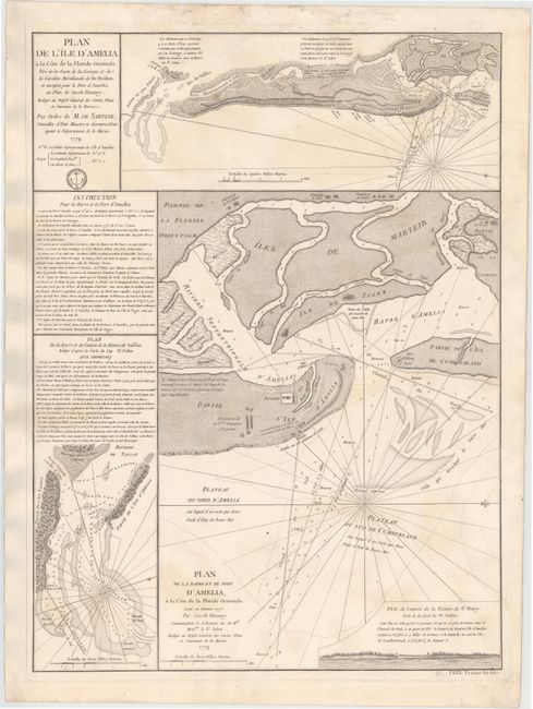
This interesting sheet has three charts based on the surveys of Jacob Blamey, John William Gerard de Brahm and Captain William Fuller. The plans contain soundings and navigational information on Amelia Island, which is strategically located on the boundary between Florida and Georgia. The natural deep harbor on the north end of Amelia Island was an important anchorage for all kinds of sailing vessels including smugglers, pirates, and slave ships during the colonial period. During the American Revolution, the island became home for English Loyalists fleeing the colonies.
All three charts are oriented with north to the right. The map at top shows Amelia Island from the surveys of Blamey and De Brahm. The largest chart details the harbor at the north end of Amelia Island with Cumberland Island, Martin's (Marteirs) Island and Tiger's Island, showing anchorages, soundings and hazards. The ruins of Fort William are noted at the tip of Cumberland Island. This fort was built by the British Gen. James Oglethorpe, founder of the colony of Georgia, who successfully repelled Spanish troops from Georgia in 1742. A number of other landmarks and buildings are named, including the plantation of the Countess Dowager of Egmont. A small prospect of the entrance to St. Mary River is included. The small plan to the left details the entrance of Nassau and St. Johns rivers at the southern end of Amelia Island.
Ordered by Antoine de Sartine, Minister of Marine during the American Revolutionary War. It was prepared for the very rare atlas, Neptune America-Septentrional, and separately issued for "Prix Trente six sols" as noted below the bottom neatline. The map was designed for use by both the French navy and merchant marine.
References: Sellers & Van Ee #1634.
Condition: B+
Heavy, watermarked paper with light soiling and faint damp stains entering 1 to 2" into image at top and at right.