"Planisphaerium Terrestre cum Utroque Coelesti Hemisphaerio, sive Diversa Orbis Terraquei...", Zurner, Adam Friedrich
Subject: World
Period: 1700 (circa)
Publication:
Color: Hand Color
Size:
23 x 20 inches
58.4 x 50.8 cm
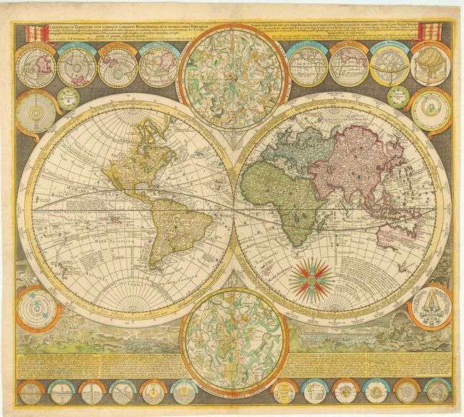
This is a stunning double hemisphere world map with up-to-date cartography for the period. California is shown as an island with an indistinct Fretum Anian and Terra Esonis above it. There is a River of the West emptying into a small sea just northeast of California. Australia is shown to be separate from New Guinea, Carpentaria and Diemens Land. Nova Britannia is shown as a separate island off the coast of New Guinea with the notation that it was discovered by Dampier in 1700. Several explorer's tracks are traced, including Magellan, Dampier, Tasman, Gaetani and Charmont. The map is enclosed in broad bands containing information on the winds and climates. Tucked between the hemispheres are beautiful celestial maps and arrayed throughout the border are twenty-six smaller astronomical diagrams and world maps on various projections. At the bottom is a panorama illustrating tempests, earthquakes, tides, vortices, volcanoes with a textual commentary on the natural phenomena depicted.
References: Shirley #639.
Condition: B+
A slightly uneven impression in lower celestial hemisphere with a long centerfold separation at bottom that has been professionally repaired. There are additional professional repairs in blank margins to small chips and tears, a few of which enter 1/8 - 1/2" into map.