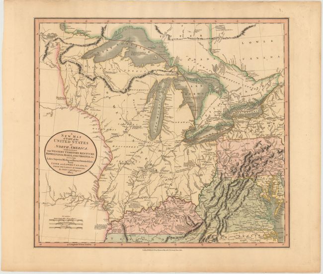
"A New Map of Part of the United States of North America, Exhibiting the Western Territory, Kentucky, Pennsylvania, Maryland, Virginia &c. Also, the Lakes Superior, Michigan, Huron, Ontario & Erie; with Upper and Lower Canada &c.", Cary, John
Subject: Central United States, Great Lakes
Period: 1805 (dated)
Publication: New Universal Atlas
Color: Hand Color
Size:
20.3 x 18 inches
51.6 x 45.7 cm
By the time of the Revolutionary War, the practice of awarding bounty land as an inducement for enlisting in the military had been a long-standing practice in colonial North America. Besides imperial bounty land grants, both colonial and municipal governments routinely compensated participants in and victims of military conflicts with land. Land was a commodity in generous supply, and governments seized upon its availability for accomplishing their goals.
Following this tradition, the Revolutionary governments used bounty land grants in their struggle for independence from Great Britain. They generally offered free lands in exchange for military service, provided they were victorious in their struggle. Thus, bounty lands were an effective technique for enrolling support for the war and encouraging re-enlistments. Generally the bounty lands were located on the western frontier, which provided another benefit to the government. Populating the frontier with citizens skilled in defense offered the best prospect in enticing other settlers to join them, thus eventually increasing the tax rolls.
This map shows the early frontier during a period when the young United States was rapidly settling the territory between the Allegany Mountains and its boundary on the Mississippi River. The present-day states of Michigan, Indiana, Ohio, Illinois, Wisconsin and part of Minnesota are all contained within the large Western Territory. Lake Superior still shows the imaginary Isle Philippeaux, and native tribes are named throughout the map. Bounty Land Grants for the Illinois Company and the Wabash Company are named near the Illinois and Wabash rivers. Navigational and historical notes are scattered throughout the map, and roads are well-delineated. One of the most interesting of those notations is one in Kentucky that describes the region discovered by J. Macbride in 1754, explored by Daniel Boon in 1769, and settled by Boon and 'five others' in 1773.
References: Phillips (Maps) p. 875; Manasek #93.
Condition: A
Lovely original color on sturdy paper with a few tiny spots in the image.