Scarce Woodcut Version of Ortelius’ World Map
"Typus Orbis Terrarum", Belleforest, Francois
Subject: World
Period: 1575 (published)
Publication: La Cosmographie Universelle de Tout le Monde…
Color: Hand Color
Size:
19.5 x 13.2 inches
49.5 x 33.5 cm
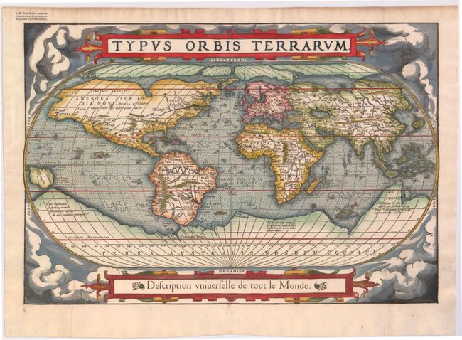
This striking world map is a woodcut copy of Ortelius' 1570 map with the same title (see Shirley #122). Placed on a cloud background, the map shows North America as much too wide and South America retains the unusual bulged southwestern coastline. At the poles, a prominent Northwest Passage snakes its way south of the four islands making up the arctic regions, and a huge Terra Australis Nondum Cognita makes up the imaginary southern continent. A notation next to New Guinea notes that it is unknown if this large island is a part of the southern continent. Belleforest has replaced Ortelius' quotation from Cicero with a French title below the map. This map was published in Belleforest's French translation of Sebastian Munster's Cosmographia. There was only one edition of Belleforest’s Cosmographie, thus the map is scarce and seldom available on the market. Instructions to the binder are included in the top left blank margin.
References: Shirley #135; Pastoureau, Belleforest #I-1, [1].
Condition: B+
Issued folding, now pressed, on watermarked paper with good margins and a couple of small spots. There are professional repairs to two tiny holes at fold intersections and a small hole along centerfold at bottom of map, with a small amount of image expertly replaced in facsimile.