Catalog Archive
Auction 142, Lot 76

"Wales", Aleph

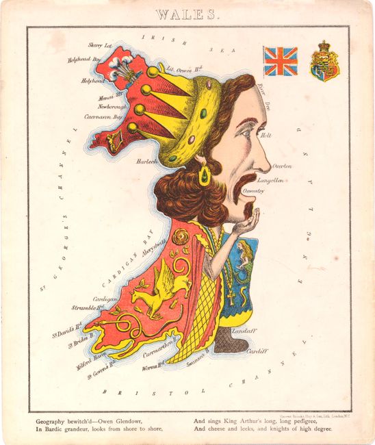
Subject: Cartographic Miscellany

Period: 1869 (circa)

Publication: Geographical Fun, Humorous Outlines of Various Countries

Color: Printed Color

Size:
7.8 x 10.2 inches
19.8 x 25.9 cm
Download High Resolution Image
(or just click on image to launch the Zoom viewer)

Satirical political maps appear throughout cartographic history and gained popularity in the latter part of the nineteenth century. This is one in a series of twelve maps of Europe that depicted the political geography in human form. The idea for the maps originated from a young girl's drawings made to amuse her sick brother. Aleph, the pseudonym for William Harvey, compiled the maps and wrote the verses that accompany them. According to his introduction, the illustrations were meant as a humorous, educational aid in the study of geography, rather than the political satire they became. Harvey's publication first appeared in 1869, published by Hodder & Stoughton with the maps printed by the firm of Vincent, Brooks, Day & Son.

This colorful chromolithograph depicts Wales as Owen Glendowr, the self-proclaimed Prince of Wales at the turn of the 15th century. While he was defeated by the English only a few years later, he became a Welsh hero during the resurgence of nationalism in the 19th and 20th century. Below the map is the verse:

Geography bewitch'd - Owen Glendowr,
In Bardic grandeur, looks from shore to shore,
And sings King Arthur's long, long, pedigree,
And cheese and leeks, and knights of high degree.

References: Hoppen #32; cf. Manasek #115; cf. Slowther (Map Collector 16), p. 48.

Condition: B+

There is light show-through from some ink drawings made on verso.

Estimate: $250 - $325

Sold for: $180

Closed on 11/28/2012

Archived