Catalog Archive
Auction 142, Lot 647

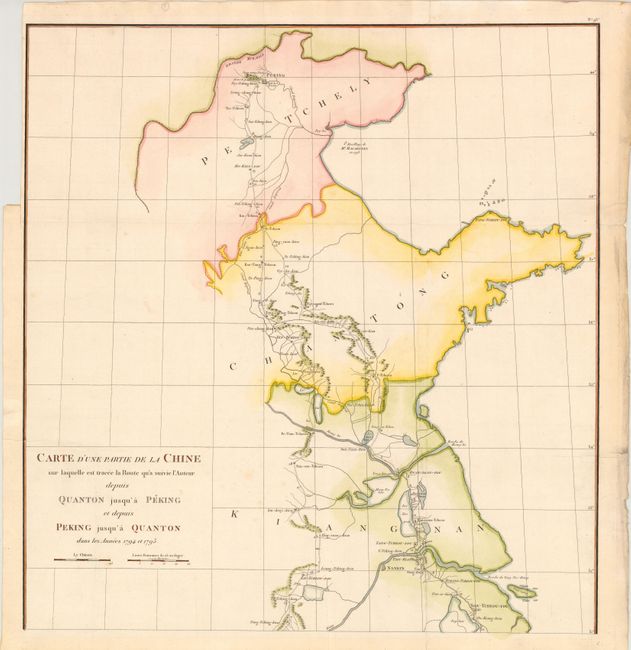
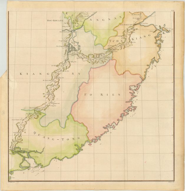
"[On 2 Sheets] Carte d'une Partie de la Chine Sur Laquelle est Tracee la Route qu'a Suivie l'Auteur Depuis Quanton Jusqu'a Peking et Depuis Peking Jusqu'a Quanton dans les Annees 1794 et 1795",

Subject: Eastern China

Period: 1808 (published)

Publication: Voyages a Peking, Manille et l'Ile de France…

Color: Hand Color

Size:
20.2 x 21 inches
51.3 x 53.3 cm
Download High Resolution Image
(or just click on image to launch the Zoom viewer)

This scarce two-sheet map depicts Chretien Louis Joseph de Guignes' journey through eastern China from Canton (Guangzhou) to Beijing. In 1784 de Guignes traveled to China as Resident of France in China and consul at Canton. From 1794-95, de Guignes served as an interpreter while traveling through eastern China with Isaac Titsingh, the Dutch ambassador to the court of the Qianlong Emperor of China. Heading to Beijing to celebrate the sixtieth anniversary of the Qianlong Emperor's reign, Titsingh and his colleagues conformed to the demands of the Chinese court etiquette and succeeded in developing good relations with China. De Guignes and the members of the Titsingh mission were the last European diplomats to appear before the Imperial court until after the Opium Wars of the next century. During his journey, de Guignes made observations on Chinese history, society and culture, geography, economics, and manufacturing. Upon returning to France in 1801, de Guignes published an account of his 17 years of travels through China, the Philippines, and Mauritius in Voyages a Peking, Manille et l'Ile de France, faits dans l'intervalle des annees 1784 a 1801.

This map is one of five included in de Guignes' account, and is the only map depicting the journey from Canton to Beijing and back. There is good detail of lakes, rivers, mountains and towns along the route, and travel dates are also marked. A note offshore of present-day Hebei province (here called Petchely) depicts where George Macartney, the first envoy of Great Britain to China, anchored his ship in 1793. The famous Macartney Embassy was aimed at easing trade restrictions between Great Britain and China, but was unsuccessful. Drawn by de Guignes and engraved by D'Houdan (Doudan). We have found no separate examples of this map appearing on the market in the last 30 years, and only a few examples of de Guignes' complete work.

References:

Condition: B

Issued folding, now pressed, on watermarked paper. The maps are clean and bright with attractive color. A binding trim at top left of each sheet has left narrow margins, but still ample for framing. The southern sheet has a 1" binding tear that has been closed on verso with old paper. The versos of the sheets are toned, causing the southern sheet to be a bit brittle with a crack that enters 1" into image at bottom that has been closed with archival tape.

Estimate: $1,500 - $2,000

Unsold

Closed on 11/28/2012

Archived