Catalog Archive
Auction 142, Lot 334

Rare Chart of San Juan

"Plano de Puerto-Rico: Dale a Luz [on sheet with] Parte de la Isla de Puerto-Rico", Lopez de Vargas Machuca, Thomas (don)

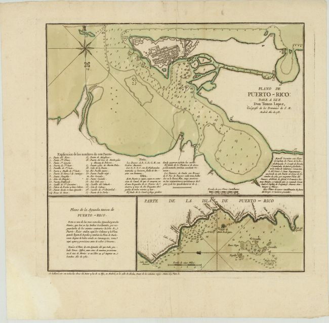
Subject: San Juan, Puerto Rico

Period: 1785 (dated)

Publication:

Color: Hand Color

Size:
14.5 x 14 inches
36.8 x 35.6 cm
Download High Resolution Image
(or just click on image to launch the Zoom viewer)

This rare sheet with two charts of Puerto Rico was published by Lopez de Vargas Machuca (1730-1802), Geographer to the King of Spain and one of the most distinguished Spanish cartographers of the eighteenth century. The top chart depicts the waters surrounding San Juan with soundings and navigational hazards. A bird's-eye plan of the city is depicted, with surrounding fortifications and a numbered key identifying 27 locations. Lopez based his map off of the manuscript map by Francisco Ramon Mendez, Primer Piloto of the Royal Spanish Armada. Mendez surveyed the area in December 1782 aboard one of the most famous Spanish War ships of the period, the San Juan Nepomuceno.

The bottom chart depicts the western coastline of the island from Rincon to Cabo del Aguila, known as the Aguada Nueva. This chart was based on the work of Thomas Jefferys from his 1762 Plan of the Aguada Nueva de Puerto Rico.

References: Shirley (BL Atlases) #T.LOP-2a [95].

Condition: B+

Original color on watermarked paper with one small worm hole in image (in numbered key) and a light crease. There is an archivally repaired hole in top blank margin and another small worm hole in right blank margin.

Estimate: $1,500 - $1,800

Sold for: $1,700

Closed on 11/28/2012

Archived