Catalog Archive
Auction 142, Lot 292

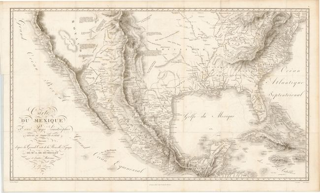
"Carte du Mexique et des Pays Limitrophes Situes au Nord et a l'Est Dressee d'apres la Grande Carte de la Nouvelle Espagne", Humboldt, Friedrich Heinrich Alexander von

Subject: United States & Mexico

Period: 1811 (published)

Publication: Atlas Geographique et Physique du Royaume de la Nouvelle-Espagne

Color: Black & White

Size:
28.5 x 16.6 inches
72.4 x 42.2 cm
Download High Resolution Image
(or just click on image to launch the Zoom viewer)

This is one of Alexander von Humboldt's important early maps of the Southwest. It covers the southern United States and Mexico and also includes the Bahamas, Cuba and Jamaica. The focus of the map however is the Viceroyalty of New Spain, which included Texas, Louisiana, New Mexico and California. While residing in Mexico City in 1804, Humboldt searched the Spanish and Mexican archives for geographical information that he compiled into his maps of the region. This map is often overshadowed by its companion map from this book, the Carte de la Nouvelle Espagne, which focuses on a smaller region with greater detail. Nonetheless, this is still a very scarce and important contribution to the cartographic history of North America. Drawn by Jean Baptiste Poirson and engraved by Barriere and Aubert.

References: Cohen pp. 100-101; Wheat #275.

Condition: B+

Issued folding with a binding trim and a binding tear that enters 1.5" into an unengraved area of map at left and has been repaired on verso with archival material. Light offsetting.

Estimate: $2,500 - $3,250

Unsold

Closed on 11/28/2012

Archived