Catalog Archive
Auction 142, Lot 123

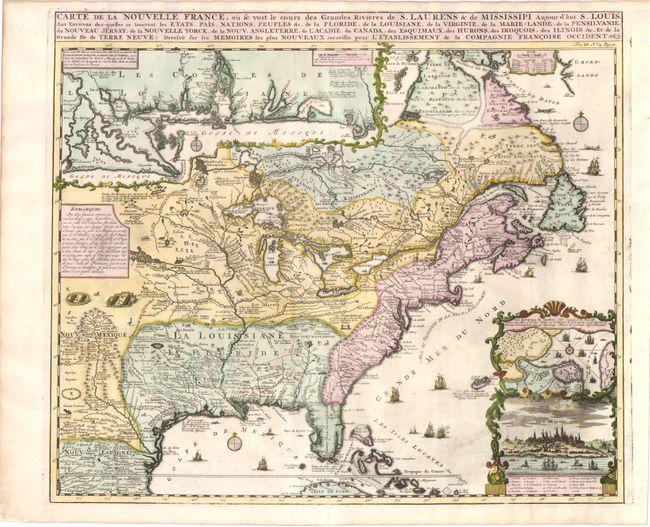
"Carte de la Nouvelle France, ou se voit le cours des Grandes Rivieres de S. Laurens & de Mississipi Aujour d'hui S. Louis, aux Environs des-quelles se trouvent les Etats, Pais, Nations, Peuples &c.", Chatelain, Henry Abraham

Subject: Colonial United States and Canada

Period: 1719 (circa)

Publication: Atlas Historique…

Color: Hand Color

Size:
19.3 x 16.5 inches
49 x 41.9 cm
Download High Resolution Image
(or just click on image to launch the Zoom viewer)

Derived from Nicholas de Fer's important four-sheet map of 1718, this is the most informative map of the French possessions in North America in the early 18th century. Louisiana and the Mississippi Valley are based on Delisle's manuscript map of 1701, while the geography of New England and eastern Canada originates with Franquelin. Inset at top left is a large-scale map of the Mississippi Delta and Mobile Bay, based on the voyage of Pierre Le Moyne d'Iberville. Another inset plan and view of Quebec is enclosed in a very decorative cartouche at bottom right. The map is filled with wildlife, scenes of Indians hunting, Indian villages and notations, and the oceans are embellished with numerous ships, canoes and sea monsters. It was issued to promote the recently established Compagnie Francoise Occident, which was formed to fund the debt of Louis XIV and offered inducements to encourage settlement in Louisiana.

References: Verner and Stuart-Stubbs #11; Kershaw #332; McCorkle #719.4.

Condition: A

A fine impression and attractive color. Some minor worming along the centerfold has been expertly repaired with leaf-casting and a few letters of expert facsimile.

Estimate: $2,000 - $2,400

Sold for: $1,500

Closed on 11/28/2012

Archived