Catalog Archive
Auction 141, Lot 150

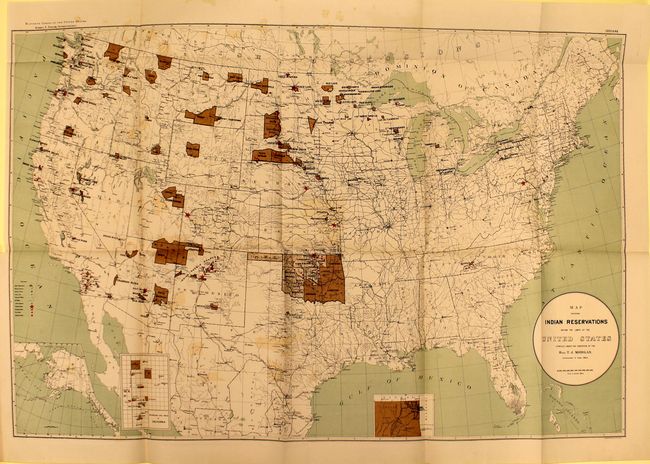
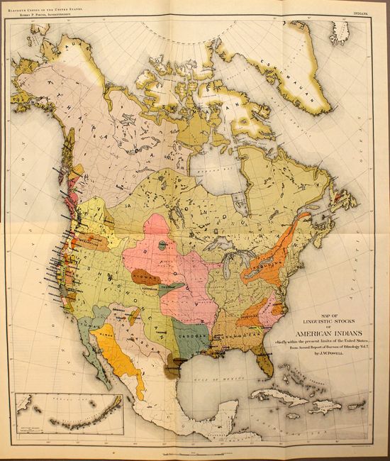
"[Lot of 2] Map Showing Indian Reservations within the Limits of the United States [and] Map of Linguistic Stocks of American Indians Chiefly within the Present Limits of the United States", U.S. Government

Subject: United States

Period: 1890-94 (published)

Publication:

Color: Printed Color

Size:
See Description
Download High Resolution Image
(or just click on image to launch the Zoom viewer)

A. Map Showing Indian Reservations within the Limits of the United States, (33.5 x 21"). This large map of the United States focuses on the many Indian Reservations in the United States in 1894. The reservations are named and shown in dark brown overprinting. Inset maps are used where the reservation concentration prevents them showing well on the main map. Insets include Indian Territory, the Mission Indian Reservations in California, and the Territory of Alaska. An extensive legend locates Military Stations, Capitals, County Seats, Railroads, Indian Agencies, Training Schools, Boarding Schools, Day Schools and Contract Schools. Compiled under the direction of T.J. Morgan Commissioner of Indian Affairs and printed by Sackett & Wilheims Litho Co., New York. A large and very detailed map filled with information. Condition: Offsetting with a short binding tear that just touches neatline. (B+)

B. Map of Linguistic Stocks of American Indians Chiefly within the Present Limits of the United States, (17.5 x 20.3"). This colorful and useful map is helpful in understanding the early relationships of the various Native American tribes. While covering most of North America, the focus of the map is the Native American tribes of the United States. A small inset shows the Aleutian Islands at lower left. Chromolithographed by the New York firm of Sackett & Wilhelms. The map was compiled under the direction of Henry Gannett, who established the geography program in the U.S. Census Office for the tenth (1880) census. In 1882 he created a similar program at the USGS, which became the Division of Geography in 1885 and produced the first topographic map sheets published in the General Atlas of the United States four years later. This is the increasingly rare issue of this map that was issued in the 11th Census, circa 1890-91. Condition: (A)

Included with these maps is 42 pp. of disbound introductory text and 3 smaller maps within the text (2 single-page and 1 double-page map). Condition: (A)

References:

Condition:

See description above.

Estimate: $250 - $350

Sold for: $160

Closed on 9/5/2012

Archived