Catalog Archive
Auction 140, Lot 650

"Neu-Geographisch Vorgestelltes Ungarisches Kriegs-Theatrum in Servien und dem Bannat Temeswar ... 1716 und 1717", Homann, Johann Baptist

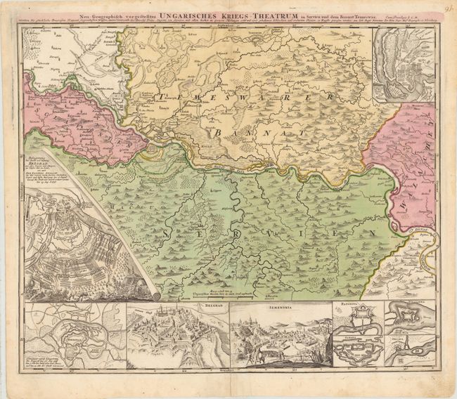
Subject: Balkans, Serbia, Romania

Period: 1720 (circa)

Publication:

Color: Hand Color

Size:
22.5 x 19.3 inches
57.2 x 49 cm
Download High Resolution Image
(or just click on image to launch the Zoom viewer)

This fascinating map depicts the Siege of Belgrade from 1716 to 1717, which occurred during the Austro-Venetian-Ottoman war. The battle ended on August 17, 1717 with Belgrade, an important stronghold for the Ottoman Empire, falling into Austrian control under the command of Prince Eugene of Savoy. The main map depicts the region with Belgrade at left, Temeswar at top, and the Danube River flowing through the center. The map features 9 insets, including the battle plans of the Siege of Belgrade and the Battle of Peterwardein (Petrovaradin), and bird's-eye views of the fortifications of Temeswar, Belgrade, Semendria, and several other towns.

References:

Condition: B+

Original color and watermarked paper with a few faint spots and a hint of toning along centerfold. There are two centerfold separations that enter 3" and 4" into map that have been closed on verso with archival materials.

Estimate: $300 - $400

Sold for: $500

Closed on 5/23/2012

Archived