Catalog Archive
Auction 140, Lot 53

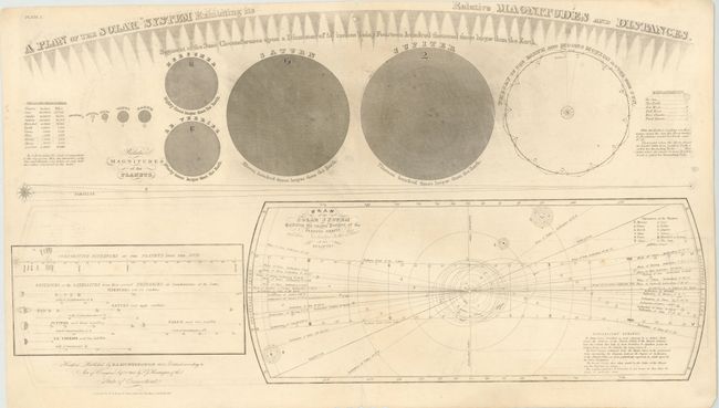
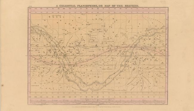
"[Lot of 2] A Plan of the Solar System Exhibiting its Relative Magnitudes and Distances [and] A Celestial Planisphere, or Map of the Heavens", Burritt, Elijah H.

Subject: Celestial

Period: 1835 (dated)

Publication: Atlas Designed to Illustrate the Geography of the Heavens

Color:

Size:
See Description
Download High Resolution Image
(or just click on image to launch the Zoom viewer)

These two charts are from Burritt's popular star atlas, which was intended for the general public, rather than for professional astronomers. Only the brighter stars and nebulae, and their allegorical forms, were depicted on the charts. The charts were engraved by W.G. Evans and published by F. J. Huntington.

A. A Plan of the Solar System Exhibiting its Relative Magnitudes and Distances, black & white (27.5 x 15.3"). Unusual engraving that shows the relative size of each planet and distances between the planets and their satellites. Large chart at lower right details the orbits, inclinations and planes of the planets. Condition: Light offsetting and soiling, with a small hole near centerfold at top and a few insignificant chips on bottom edge of sheet. (B)

B. A Celestial Planisphere, or Map of the Heavens, hand color (20.5 x 14.5"). This star chart shows the Ecliptic Line crossing the sky from east to west, the Milky Way, and dozens of constellations filling the sky. Along the bottom is a scale identifying the sun's place in the Ecliptic for each day of the year and shows the signs of the Zodiac with their astronomical symbols. Engraved by W. G. Evans under the direction of E. H. Burritt. Condition: Light offsetting and a minute separation along centerfold, only visible when held up to light. A better condition than we typically see for this piece. (A)

References:

Condition:

See description.

Estimate: $120 - $180

Sold for: $65

Closed on 5/23/2012

Archived