Catalog Archive
Auction 140, Lot 193

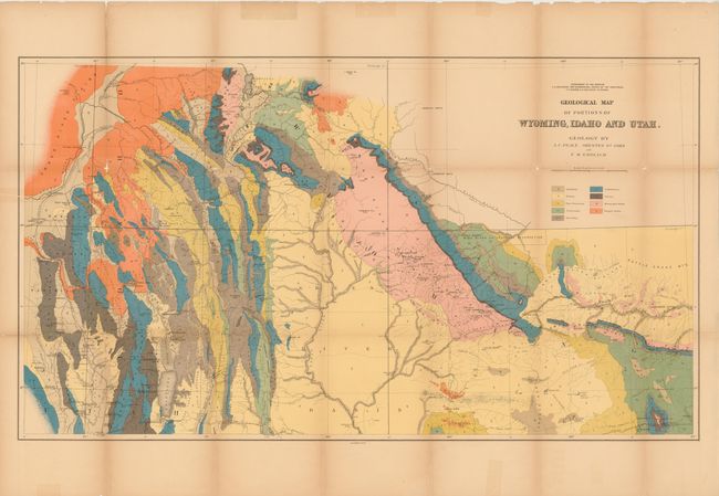
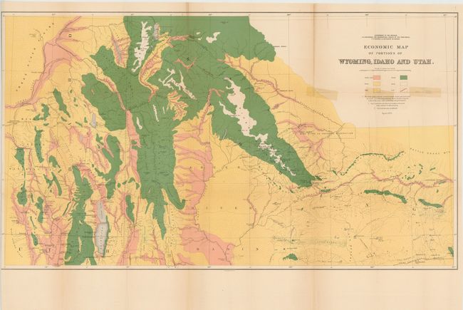
"[Lot of 2] Geological Map of Portions of Wyoming, Idaho and Utah [and] Economic Map of Portions of Wyoming, Idaho and Utah", Hayden, Ferdinand Vandeveer

Subject: Western United States, Wyoming, Idaho, Utah

Period: 1879 (circa)

Publication:

Color: Printed Color

Size:
36.5 x 20.5 inches
92.7 x 52.1 cm
Download High Resolution Image
(or just click on image to launch the Zoom viewer)

Geological Map of Portions of Wyoming, Idaho and Utah was one of ten maps included in Hayden's 12th Annual Report published in 1883. It is a handsome and colorful map that focuses on part of Idaho eastward to the Sweetwater Range. Topography and hydrology are nicely developed and an abundance of towns and villages are shown. Bear Lake is at lower left bordering Idaho and Utah, and Rawlings is at lower right with a portion of the Union Pacific Railroad detailed. The map locates wagon roads, trails, sand dunes, and has fine watershed details. Mining activity is clearly shown in place names like Miner's Delight, Camp Stambaugh, Atlantic City, etc. Other place names include Blackfoot, Rose Fork Agency (Fort Hall), John Gray's Lake, Caribou, and the Wind River or Shoshone Reservation. Taylor's Bridge on the Snake River pre-dates Idaho Falls.

The second map, Economic Map of Portions of Wyoming, Idaho and Utah, is also from Hayden's 12th Annual Report. It is a beautifully executed chromolithographed map that details the land types of the region. The map covers the area from Jackson Lake and the Tetons in the north to Bear Lake, Logan and Robinson's Ferry on the Green River in the south, and extends from Blackfoot, Idaho in the west to Rawlings, Wyoming in the east. A color/style legend identifies land types including arable land, grass, sage, forest, and rock. Coal deposits are identified via red over printed lines. This very detailed chart drawn on a scale of 1 inch per 8 miles, with geology by A.C. Peale, Orestes St. John, and F.M. Endlich.

References: Wheat (TMW) #1296.

Condition: C+

Very fine color, folded as issued. The geologic map has fold separations that have been repaired with tissue on verso. There is one piece of cello tape on recto that is in the blank margin, well away from the image. The economic map has cello tape in the image to repair a fold separation and was trimmed nearly to the neatline for binding.

Estimate: $170 - $200

Unsold

Closed on 5/23/2012

Archived