Catalog Archive
Auction 140, Lot 123

An Important French Map Illustrating the Theater of the French and Indian War

"Carte des Colonies Anglaises dans l'Amerique Septentrionale Terminee par la Re. Ohio", Poilly, N.J.B.

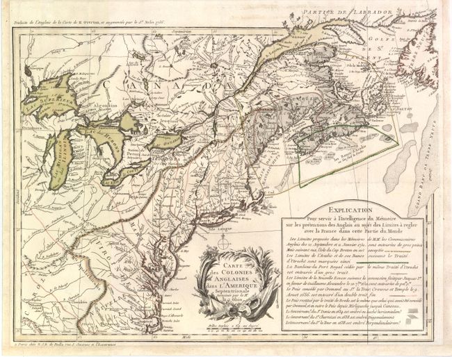
Subject: Eastern Canada & United States

Period: 1756 (circa)

Publication:

Color: Hand Color

Size:
18.3 x 14.5 inches
46.5 x 36.8 cm
Download High Resolution Image
(or just click on image to launch the Zoom viewer)

This uncommon map is one of a series of important maps that illustrate the parts of North America that were disputed between France and England during the French and Indian War. It covers the area from Labrador to Cape Hatteras and west to Lake Superior and the Ohio river valley. It shows the English colonies, Indian villages, towns, forts and rivers. The map is based upon Henry Overton's earlier map of 1754, with revisions from Nollin's map of 1756, and enlarged to include Nova Scotia and Newfoundland. The key areas of the British offensive, in what French Canadians refer to as La guerre de la Conquête (The War of Conquest), are highlighted with a lengthy explanation and color key describing the various boundaries, treaties and incursions. The map is decorated by a lovely floral title cartouche.

References: McCorkle #756.13; Sellers & Van Ee #71.

Condition: B+

Original color with a few minute wormholes. Margins have been extended at bottom and sides to better accommodate framing. Issued folding.

Estimate: $2,500 - $3,500

Sold for: $1,800

Closed on 5/23/2012

Archived