Catalog Archive
Auction 139, Lot 265

Scarce Map of Charleston and the Battle at Fort Sullivan

"A Sketch of Charleston Harbour Shewing the Disposition of the British Fleet under the Command of Vice Adm. Mariot Arbuthnot upon the Attack on Fort Moultrie on Sulivan Island in 1780", Ramsay, David

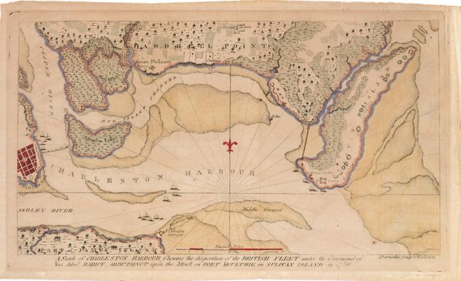
Subject: Charleston, South Carolina

Period: 1785 (circa)

Publication: The History of the Revolution of South Carolina

Color: Hand Color

Size:
11.8 x 6.5 inches
30 x 16.5 cm
Download High Resolution Image
(or just click on image to launch the Zoom viewer)

This important map of Charleston Harbor during the attack on Fort Sullivan is one of the earliest battle plans of the American Revolution, and only the second map of Fort Sullivan published in America. Charleston was a critical location as it was the largest city and only port in the South. In the summer of 1776, the British dispatched a fleet of ships to regain the possession of Fort Sullivan from the Americans. Due to tactical errors and misinformation, the British lost the battle despite the fact that they had more than double the manpower and firepower than the Americans. This map extends from Charleston in the west to Sullivan Island in the east, and depicts fortifications, land terrain, a "destroyed" Fort Johnson, and numerous ships in the harbor. Two floating bridges of boats are shown from Charleston to Shutes Folly and from Sullivan Island to Haddrell Point. Engraved by Thomas Abernathie and published in Trenton, N.J. by Isaac Collins.

References: Phillips (M) p.222; Nebenzahl, K. (Biblio Amer Rev) #81; Wheat & Brun #593.

Condition: B+

Watermarked paper with toning and fold separations that have been closed on verso with archival tape.

Estimate: $1,200 - $1,500

Sold for: $700

Closed on 2/15/2012

Archived