Catalog Archive
Auction 138, Lot 379

"Kaart van het Middelste deel van America", Dampier, William (Capt.)

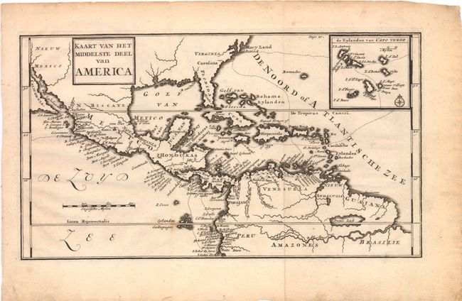
Subject: Gulf of Mexico and Caribbean

Period: 1698 (published)

Publication: Nieuwe Reystogt Rondom de Werrel

Color: Black & White

Size:
11.3 x 6.3 inches
28.7 x 16 cm
Download High Resolution Image
(or just click on image to launch the Zoom viewer)

William Dampier (baptized 1651-1715) was a buccaneer (pirate) and sea captain. He was the first Englishman to explore parts of New Holland and New Guinea, and was the first man to circumnavigate the world three times.
In the 1670s he crewed with buccaneers on the Spanish Main of Central America, which eventually led to his first circumnavigation. On the ship Cygnet, following Pacific-spanning raids that included the East Indies, Manila, and the Spice Islands, Dampier's ship was beached on the northwest coast of Australia in 1688. Waiting for repairs, his scientific interest surfaced as he made notes and drawings on the local fauna and flora. Following three years of further adventures he returned to England. In 1697 he published his experiences in A New Voyage. Described as one of the greatest tales of adventure and exploration ever written, the book was published in several languages. It is reported that Captain Cook used Dampier's nautical observations on his voyages, and Charles Darwin found his books so useful that he took them aboard the Beagle.

This is from de Hondt's rare Dutch edition of William Dampier’s voyages. The English edition's map, titled "A Map of the Middle Part of America," is identical in its depiction; this edition is re-engraved to use Dutch names. This chart shows part of the route of William Dampier's first circumnavigation voyage in the 1680s with his passage across the isthmus of Panama. The map covers the area of northern South America through Central America into what is now the southern United States with Mary-Land, Virginie, Caroline, Floride, and N. Mexique named. There is an inset map detailing the Cape Verde Islands with the route of exploration delineated.

References:

Condition: B+

Nice impression with a few minor stains and light toning in the blank margins. Issued folding.

Estimate: $275 - $350

Unsold

Closed on 12/7/2011

Archived