Catalog Archive
Auction 138, Lot 164

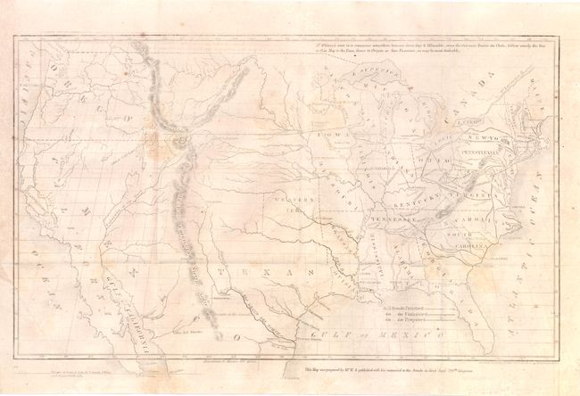
"[Map of Proposed Routes of Western Railroads]", Whitney, Asa

Subject: United States

Period: 1846 (dated)

Publication: HR Doc. 773, 29th Congress., 1st Session

Color: Black & White

Size:
15.8 x 9.5 inches
40.1 x 24.1 cm
Download High Resolution Image
(or just click on image to launch the Zoom viewer)

This unusual, untitled map of the United States shows the existing (finished and unfinished) railroads in the eastern states with a proposed railroad shown beginning at Prairie du Chein and stretching toward the Pacific through South Pass. The map portrays the United States prior to the acquisition of California and the Southwest. The map, reduced and engraved by O.H. Throop, is accompanied by the original 48 pp. report by Rep. Robert Smith to the 29th Congress in 1846.

Asa Whitney was one of the earliest backers of an American Transcontinental Railway. It was as early as 1830 that Whitney first became enthralled with railroads and foresaw their future role in business and transport. Whitney's proposed route from Lake Michigan through South Pass to the Pacific was not accepted mainly because of the growing sectionalism before the Civil War. However, the map is an important part of the railroad history of the United States.

References:

Condition: B

There is some light offsetting in the image and some isolated spots of foxing.

Estimate: $160 - $200

Sold for: $150

Closed on 12/7/2011

Archived