Catalog Archive
Auction 138, Lot 108

"A New Map of North America, From The Latest Discoveries", Carver, Jonathan (Capt.)

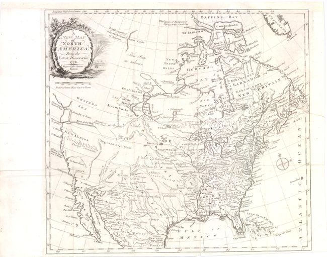
Subject: North America

Period: 1778 (dated)

Publication: Travels Through the Interior Parts of North America

Color: Black & White

Size:
14.3 x 13 inches
36.3 x 33 cm
Download High Resolution Image
(or just click on image to launch the Zoom viewer)

Jonathan Carver, who joined Robert Rogers' efforts to find a navigable route to the Pacific Ocean in 1766, is credited with being the first English-speaking explorer to travel west of the upper Mississippi River. The expedition was abandoned after wintering with the Sioux when expected supplies did not arrive, In 1778 he published the accounts of his travels in a book that is noted for first mentioning a large mountain range blocking passage to the Pacific Ocean, and serving as the Continental Divide. This uncommon map shows the route that Carver and his party was seeking with a boldly depicted River of the West connected by a dotted line to Pikes Lake, which is connected to the Mantons River (upper Missouri River). The is noted in the Pacific Northwest, but is not delineated. At top Carver also hints at a Northwest Passage, with the note "the Suppos'd Eskimeaux Passage to the South Sea." The map features a delicately engraved title cartouche with a tree overlooking a river with a sailing ship.

References: Sellers & Van Ee, #159, McGuirk #167.

Condition: B+

Issued folding, now pressed, with a minute hole at one fold intersection, and a minute pinhole only visible when held to light. A binding tear that enters 1.75" into the map image at right has been professionally repaired and the binding trim has been extended to better accommodate framing.

Estimate: $475 - $600

Sold for: $425

Closed on 12/7/2011

Archived