Catalog Archive
Auction 137, Lot 838

"Carte des Decouvertes du Capne. Carteret dans la Nle. Bretagne avec une Partie du Passage du Capne. Cook a Travers les Detroits Endeavour et de la Route et des Decouvertes du Cap. Dampierre dans la Nle Guinee et la Nle. Bretagne en 1699 et 1700", Cook, James (Capt.)

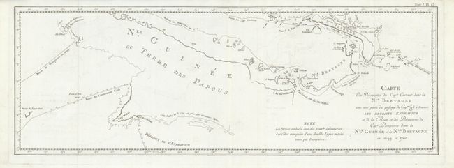
Subject: South Pacific Ocean

Period: 1780 (circa)

Publication:

Color: Black & White

Size:
24 x 8.5 inches
61 x 21.6 cm
Download High Resolution Image
(or just click on image to launch the Zoom viewer)

This is a French edition of "A Chart of Captn Carterets Discoveries at New Britain, with part of Captn Cooks passage thro Endeavour Streights…" The chart details the path of Captain Cooks voyage along the southwestern coast of the island of New Guinea in today's Irian Jaya, Indonesia's easternmost province. Cook sailed between Australia and New Guinea and proved the existence of the Strait of Torres. The chart also details the explorations of Carteret and Dampierre which focused on the northern portion of New Guinea and the nearby Pacific islands.

References:

Condition: A

Near fine example less some faint offsetting. Bright, clean paper and fine impression on thick paper with original margins.

Estimate: $140 - $180

Sold for: $70

Closed on 9/14/2011

Archived