Catalog Archive
Auction 137, Lot 716

One of the Earliest Maps of the Whole Continent of Asia

"Die Langer Asie nach irer Gelegenheit bisz in Indiam werden in disser Tafel Verzeichnet", Munster, Sebastian
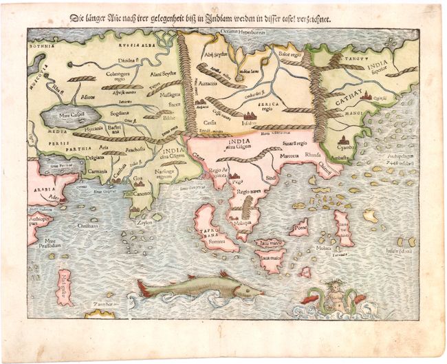
Subject: Asia

Period: 1550 (circa)

Publication: Cosmographia

Color: Hand Color

Size:
13.5 x 10.5 inches
34.3 x 26.7 cm
Download High Resolution Image
(or just click on image to launch the Zoom viewer)

This early map is based on the recent geographical discoveries by Portuguese navigators. The outline of the Asian mainland is relatively well-established, but Munster omits the extreme northeast of Asia, still believed to be joined to the New World. Japan is also lacking, as it appeared on Munster's New World map instead. India appears as a peninsula and Sri Lanka, called Zalon, is correctly located. Cambay, Goa and Cannonore are all shown, reflecting the Portuguese presence on India's west coast, and this edition names Calechut, unlike the earlier examples of the map. Malacca is correctly located on the Malay Peninsula and the Indonesian island of Sumatra has inherited the name Taprobana from Sri Lanka, but also bears the name Sumatra. Java appears as two islands, Java Maior and Java Minor, shown north of the other. The famed Spice Islands of the Moluccas are located, but oddly shaped. An archipelago of 7448 islands lies off the eastern coastline of China, from the reports of Marco Polo. A huge sea monster and a fantastic two-tailed mermaid preside over the Indian Ocean. German text and illustration on verso.

References: Yeo #2; Walter #8A.

Condition: B+

Two minor holes in blank margins along centerfold closed on verso, and minor soiling in blank margins.

Estimate: $1,100 - $1,300

Sold for: $550

Closed on 9/14/2011

Archived