Catalog Archive
Auction 137, Lot 707

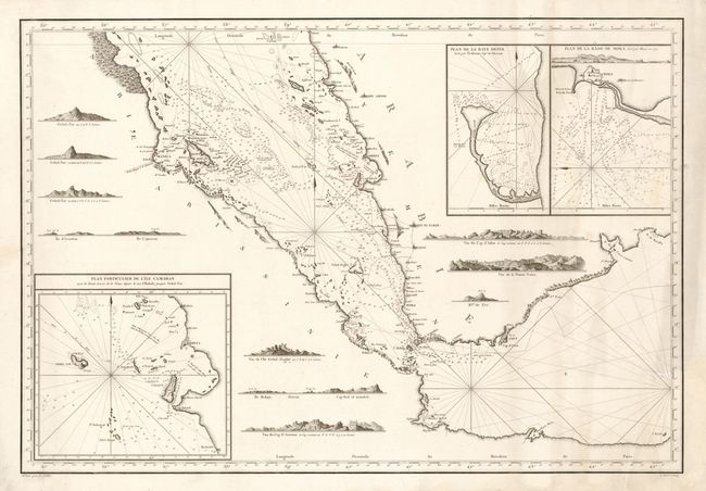
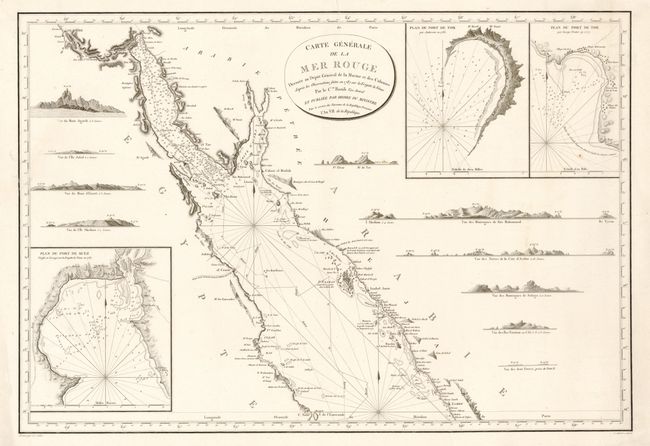
"[2 Sheets] Carte Generale de la Mer Rouge…", Depot de la Marine

Subject: Red Sea, Egypt, Saudi Arabia and Yemen

Period: 1798 (dated)

Publication:

Color: Black & White

Size:
34.5 x 23.5 inches
87.6 x 59.7 cm
Download High Resolution Image
(or just click on image to launch the Zoom viewer)

This detailed navigational chart of the Red Sea, the world's northernmost tropical sea, extends from Cairo in the north to the Gulf of Aden in the south. Printed on two separate sheets, each with its own borders, the map is based on the explorations of Captain de Rossily, who sailed the Red Sea in 1787 on the frigate La Venus. Soundings, anchorages, navigational hazards, La Venus' route and engraved views of the coastline are depicted. The northern map contains three inset maps of the Port of Suez, the Port of Tor in the Gulf of Acaba as surveyed by Anderson in 1785 and the Port of Tor as surveyed by George Trotter in 1777. The southern map includes three inset maps of the coast of Yemen, including Kamaran island, the Bay of Denis near Hudaydah as surveyed by Trobriant, and the Bay of Mocha as surveyed by Mace in 1772.

References:

Condition: B+

Wide margins on heavy, watermarked paper with marginal soiling and a few minute wormholes only visible when held up to light. The northern sheet has a professionally repaired tear at left that enters blank area of map image, with minute loss of border. The southern sheet has light soiling and two professionally repaired tears, one that enters map image 1" at left and the other that enters 3" at right.

Estimate: $400 - $500

Sold for: $275

Closed on 9/14/2011

Archived