Catalog Archive
Auction 137, Lot 332

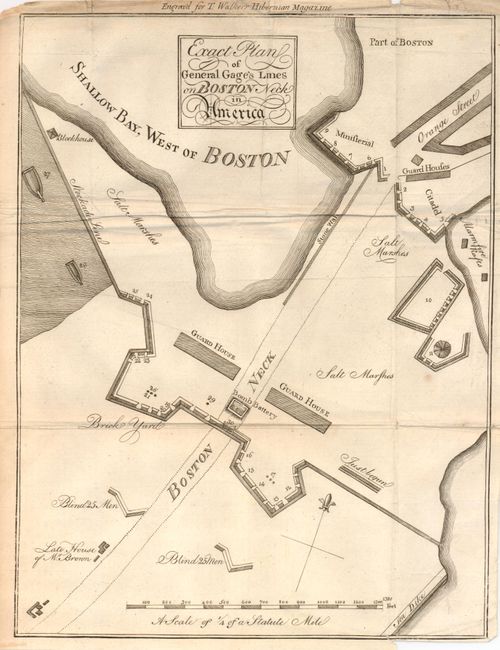
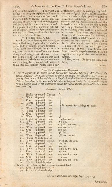
Early Plan of Boston at the Beginning of the American Revolution

"Exact Plan of General Gage's Lines on Boston Neck in America", Anon.

Subject: Boston, Massachusetts

Period: 1775 (published)

Publication: T. Walker's Hibernian Magazine

Color: Black & White

Size:
8.7 x 11.5 inches
22.1 x 29.2 cm
Download High Resolution Image
(or just click on image to launch the Zoom viewer)

This rare map depicts the British fortifications at the entrance to Boston Neck along present-day Washington Street following the battles of Lexington, Concord and Bunker Hill. The map locates the Bomb Battery, 25 men "Blinds", the salt marshes, the stockade line, and more. The original text page from the magazine (page 667) "References to the Plan of Gen. Gage's Lines" is included with this lot. The page bears a note referring to the map "This is a true state this day, July 31, 1775." It also contains a list of 30 references to the plate locating 29 guns (e.g. "12-pound Cannon 60 round shot lying to each") and the Gate and drawbridge. The fortifications and entrenchments are well shown. No engraver given. Published in the November 1775 edition of this rare Irish magazine published by Henry Farrar printed by Thomas Walker. It is a direct copy of the map from the Pennsylvania Magazine published three months earlier, in August 1775, which was one of the earliest printed maps of the Revolution.

References: Jolly HIB-4; cf Wheat & Brun 237.

Condition: B+

The map is very nice with just a little toning in upper margin. Crisp impression. The margins are close, as issued and there is a binding trim at lower right. Folding as issued with a lazy extra fold along one panel. Magazine page is lightly toned.

Estimate: $800 - $1,200

Unsold

Closed on 9/14/2011

Archived