Catalog Archive
Auction 137, Lot 280

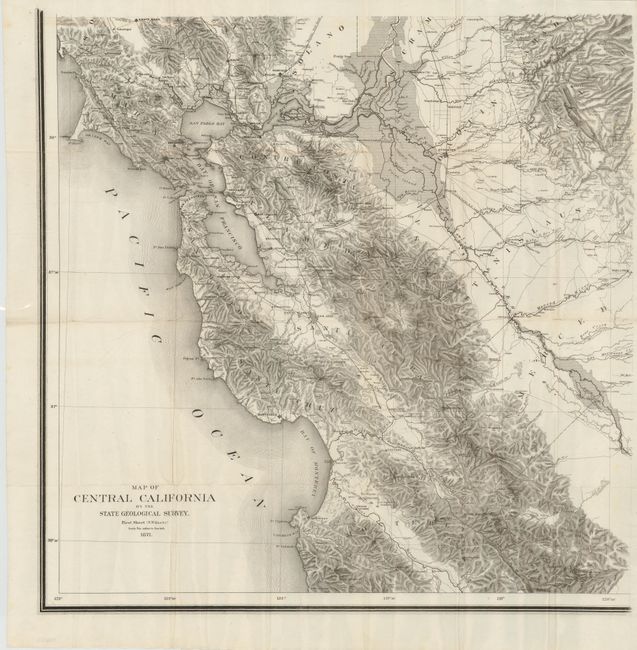
Scarce Topographical Map of California

"Map of Central California by the State Geological Survey - First Sheet (S.W. Quarter)",

Subject: California

Period: 1871 (dated)

Publication:

Color: Black & White

Size:
24 x 24 inches
61 x 61 cm
Download High Resolution Image
(or just click on image to launch the Zoom viewer)

This is the southwest sheet of a purported four-sheet set produced by J.D. Whitney and the California Geological Survey. The entire set was never completed. Only the southern two sheets were produced in the 1873 edition, and it is unclear whether anything was produced beyond the first sheet in this 1871 edition. We have not seen this map anywhere on the market in the last 25 years.

This steel engraved map covers the area from Bodega Bay to Carmel and goes inland to Snelling and north to San Andreas. The map, on a scale of 6 miles to the inch, is full of detail including towns, settlements, and watershed. There is incredible detail of topography throughout, delineated by countless hachure.

J.D. Whitney was appointed state geologist of California in 1860. While many legislators saw his role as simply uncovering gold and mineral deposits in the state, Whitney took a very scientific approach to the role. From 1864-1870, he published a well respected six-volume series Geological Survey of California which built the foundation for this map.

References: cf. Wheat #1238.

Condition: B+

The map is clean and bright with a few small splits at fold intersections. Issued folded.

Estimate: $2,500 - $3,250

Sold for: $1,800

Closed on 9/14/2011

Archived