Catalog Archive
Auction 136, Lot 329

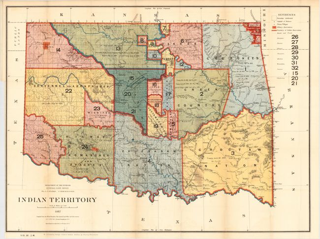
"Indian Territory", General Land Office

Subject: Oklahoma

Period: 1887 (dated)

Publication:

Color: Printed Color

Size:
32 x 24 inches
81.3 x 61 cm
Download High Resolution Image
(or just click on image to launch the Zoom viewer)

This interesting map is from the series of General Land Office maps reflecting the status of lands allocated to various tribes as shown through color-coding. The Indian Territory was initially established as a place to relocate the principal eastern Indian tribes and the Five Civilized Tribes formed the nucleus of an organized government. By 1887, however, representatives of some fifty tribes had settled on lands once promised to the original five. This map reflects many of these allocations and shows 25 separate regions and names seven more. A small portion of the panhandle is shown and labeled Public Lands. Drawn by G. P. Strum and photolithography by Julius Bien & Co., N.Y. Accompanied with the original disbound portion of the report, titled "Indian Territory, June 30, 1886" from George Catlin's Indian Gallery, by Thomas Donaldson.

References:

Condition: B+

The map has strong, bright color and full margins. Short closed tear at binding trim and a small area of darkening near center. Report is fine.

Estimate: $240 - $300

Sold for: $150

Closed on 6/1/2011

Archived